Sunday, July 6, 2014

The Braddock Road Crossing Reenactment At Connellsville


I hope everyone had a good, patriotic July Fourth!

  On the weekend of June 28 and the 29th, Connellsville held its re-enactment of General Braddock's Crossing festivities of the Yough River here, near Crawford's Cabin. I was glad to be a small part of that.


River Park Crossing area, courtesy of Penn Pilot

   Introduction

   It's doubly interesting, as I have had a post in the works for some time for the city of Connellsville anyway and that's convenient. This was a good opportunity and a meaningful experience all around, one I hadn't had before. The rock and roll music of the Del Sols was nice, they could actually play! Whiling away some time, many of the families tended to gather at booths, displays and the Balsley Pavilion, built in 2011, to beat the heat a little and enjoy some fun. This is as about as soon as this article could be done, since we are so close on the heels of July Fourth celebrations. I would like to add that The Greater Connellsville Chamber will sponsor the main fireworks there.

   Some Broader History

   In brief, during the Seven Years War of Europe, some of which played out here in what became our own unique backyard, so was being 'invaded' by the French, generous to the natives, but with long supply lines from Canada, while attempting control of the waterways and fur trade, goaded by the old claims of explorers LaSalle and Celeron.  While Pennsylvania was naturally inhabited more toward the east by the British, (and Germans, Dutch and Swiss), of the 13 royal colonies of the King of England since the 1600's, by grant of 'Penn's Woods', they were pushing westward for the prospect of more less expensive land. Once, southwestern PA was originally inhabited by the Monongehela and Woodland Cultures, and later, Algonquin, Susquehannock or Conestoga, and then some of the Iroquois from the more northern regions. And though the Seneca were the most powerful on the western corridor, first in rank were the Mohawk and the Onondagas; the Leni Lenape, and sub clans, which held the Munsees; and the Kanhawhas. As well, the nearby areas were visited on the periphery at times by other tribes and sub tribes passing through, such were the Shawnee, Wyandot and Nanticokes, with mixed clans of varying allegiences and agendas, such as the Mingos. As things stood, the provincial situation here in the Ohio Valley west of the Alleghenies was becoming a crucial hotbed and violence and bloodshed was honing in on the surrounding pioneers.

  Now that we have laid some groundwork for the urgency of the route taken and this crossing of the Youghiogheny River, I will leave off to relate the recent adventure of a tamer nature to this very place. (some research gained from 'The Indian Wars of Pennsylvania', C. Hale Sipe).


    My Lone Route

   So, down I went by Route 119, heading to the car park and turning right after a very mild crossing of my own on the Memorial Bridge on the west side of the city. Having  camera in hand, and some beef jerky, with the temperatures hovering in the mid 80's, and in need of a cold drink, I had my eye out for a parking spot. The forecast predicted foreboding thunderstorms and I wondered what treatment that weather would receive by the powers that be, centered around something to do with splashing through a river of water with lightening all around!

                                           The Festival

Yough River Park
    At the Yough River Park area, they had a nice Art on the Yough show, which I didn't really have time to take in. About 12 p.m. the Historical Society began speaking, (and speaking...), and thus began the ceremonials preliminary to the actual crossing itself at 1 o'clock.


A very exciting take on the colorful fording here, I might add! It gets the kids out of the history book mode, away from the video games and bringing to life a pretty fair impression of the reality behind the festival. It may of been marred ever so slightly by so many of the 'rent-a-cops', (no disrespect), and the presence of numerous firemen in the river.


   Add to that, the very long bright yellow rope the whole way across, well it does lose something in the translation. I looked longingly, but failed to find Mr. Braddock or his horse.


   Here you can also see the rafters interfering a bit on their journey down river.

Don't shoot, we're not French!


   But, with the shouting, band playing, splashing and shooting, hot damn, this felt right up my alley. All in all, it was enjoyable, especially the puzzling continual shooting of the muskets by the interestingly attired colonial re-enactors.


musket fire at Braddock's Crossing


Keep that flag held high!

    I'm not sure who was who exactly, but you would suppose this might of been a needed consideration for extra drama; and it does get your attention.


the British are coming


some good reenactors at the festival posing for a photo


       The recreation of Col. Crawford's 1766 cabin:
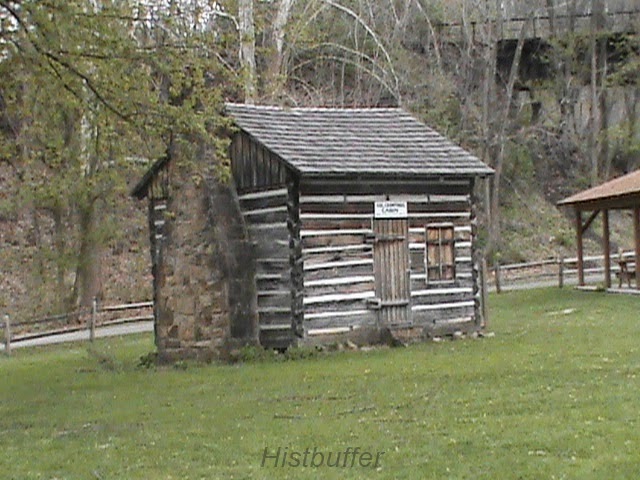
recreation of Colonel Crawford's Cabin


Crawford at the Carnegie Library

                                  Historical Background

   For the nitty-gritty, historically speaking, linking up to the Greater Allegheny Passage, locally, you can follow the Heritage Trail signs on the west side around a two mile area and ride or walk to take in the sights. The British themselves, were busy following the Nemacolin Indian path and part of the Catawba Trail; the exciting tale of the breaking and forging of Braddock's Road up a mostly, northwesterly route, through Fayette and Westmoreland during the heat of the French and Indian War, in 1755. This truly historic route would become the National Pike, then the future Route 40 and U. S. 68.

   Briefly, one Major General Edward Braddock, (1695- 1755), of the Coldstream Guards:


Major General Edward Braddock, courtesy, Wiki Commons

   He was responsible for launching the Expedition to defeat the French and Indians, (including Seneca, Mingo, Shawnee and some Delaware tribes), and with 21 year old George Washington, recently of Fort Necessity who had scouted the region well for Virginia previously with Christopher Gist, now as aide de camp and a Major, and, at least, part of the way, a young wagoner named Daniel Boone, Colonel Thomas Gage, Captain Horatio Gates, future commander of the continental forces and Indian guides, on the long march to the forks of the Ohio, with roughly, 2,600 troops, baggage, wagons and artillery, was assigned to the colonies for the taking of Fort Duquesne. Widening the road as they moved along, Colonel Dunbar was assigned the control of the artillery and some of the heavier supplies on Chestnut Ridge.

   This led to the fateful encounter in July and surprising ambush at the three hour Battle of the Monongehela, with approaching 900 casualties, the Major General severely and mortally wounded and the hasty, disorganized retreat; Braddock's burial by Colonel George Washington, and quick journey back to Will's Creek, Maryland. Much else can be said of the cutting of the wider road, the unfortunate tactics at the Field of his name, Dunbar's over reaction to the oncoming danger posed by the French, etc. We are here to concentrate our attention to the after affects of the following of Stewart's earlier Crossing here near Colonel Crawford's historic cabin in what was said to be three feet of water at the Yough Park, an area full of historical significance, at the 2014 June Festival at Connellsville, Fayette County, separated in time, hundreds of years later.


The route was also used as part of the Underground Railroad, to help escaping slaves in the 1800's and today is a good place with swimming, biking, hiking and fishing.

   Coming from the area of Mt. Braddock on Laurel Ridge, past Gist's Plantation, and Robinson's Falls at New Haven where the army camped and before the next camp at the Narrows, a mile towards the north, you come to Stewart's Crossing on the Youghiogheny River. More information here. Information on Mt. Braddock and Gist here.


    William Stewart was an early settler on the western side of the Yough River, near Opossum Run and Mount's Creek in what became Connellsville in 1753.

    A tragedy of a different sort involve a Scots-Irishman, Colonel William Crawford, 1732-1782, an early surveyor and soldier with connections to Washington and his Virginia Regiment. Tortured by the Indians and tragically burned at the stake in Sandusky, Ohio. He also fought in the Revolutionary War.


fireplace in Crawford's cabin
    This is done in honor of the work of a man and an army of what were then British soldiers in colonial days of yore. Washington had said of him later, in retrospect, "Thus died a man, whose good and bad qualities were intimately blended. He was brave even to a fault and in regular Service would have done honor to his profession. His attachments were warm, his enmities were strong, and having no disguise about him, both appeared in full force."


     It was a great learning experience for the young and old. We are seriously indebted to the Connellsville borough, Historical Society and the Fayette County Cultural Trust for holding the meaningful and cultural event there, as well as all the other sponsors.

    Any of you that were here this weekend, please go ahead, be proud and leave a comment with a little of what you thought of the event and what all you did.

    Here's some more of the action:

best I could do as it was a bit crowded


Indian hut with Colonial and Indian weapons

.
Native American at the Yough

Not Robin Hood and Little John here!

old days of Pennsylvania fire power

seller of Indian artifacts and Native American goods (I bought some)

animal pelts for the rendezvous

ready for the Narrow's encampment ?

C'mon, hurry back for the BBQ, boys!


   The Connellsville post will be up sometime soon, just don't get impatient. And in the mean time, I do have a few other plans in the pipeline. So, stay tuned and check back!
    - Histbuffer

Coal, Coke and Colonel Crawford: A Post On Connellsville


Some Historical Reflections of Connellsville


 Introduction


    I meant for some time to get to this important city of Fayette County, but one item or another kept me from giving it all my attention and resources. So, I got out my camera and a few maps and delved deeper into the subject.

   This post is about the unique history of Connellsville, once a large borough north of Uniontown, the county seat. It was incorporated in 1806, in Fayette County Pennsylvania and in 1906 became a city. It is beyond our scope to attempt a significant rundown from A-Z, so a patchwork of the region will have to suffice. Any locals that would like to add something interesting, please help to fill in the blanks.

   [NOTE: The borough of South Connellsville will be a subject for future coverage]

Very Early Days


   The city that joined with New Haven about 1917 is as interesting in details as it can be captivating in it's depth.  Lying near the heart of what is termed the Connellsville Coalfield, the borough is partly circled on the west by the Youghiogheny River, an important resource that called people to the area and to where many started settling in the late 1770's. This included the French from the north as well who claimed this land and the Delaware, Shawnee and Kanhawas and other tribes of Indians who were here even earlier. The coal strike labor dispute situation in 1891, led to some serious violence.

    The timber was a real attraction, especially the oak trees and, of course, the coal and ore production. The coal was baked to harden into coke, thereby used to smelt the iron ore. This was the custom all around the area.

                                   
courtesy, Library of Congress

   The fur trade was very popular too. The Catawba Indian Trail crossed through the region and the Ohio Company were heavily involved in exploring as they also hunted and trapped. Christopher Gist had major involvement as a surveyor from Virginia and then as a resident. He was a confidante, guide and friend of a young George Washington, who himself a surveyor, passed through here by way of Stewart's Crossings at different times, on his way to Le Beouf and later, Fort Duquesne experiencing much of the regional places and customs leading up to the  French and Indian War.

   Here's an historical marker for Jumonville:


courtesy of explorehistory.com
     And here's an historical marker for Braddock's Twelfth Camp here: (and two markers are better than one!)

explorehistory.com
                    
                                         
   General Braddock's march led through his army through here and forded the Yough River at Stewart's Crossing. There, will be found Colonel Crawford's Cabin, though reconstructed, and the remnant of road named for his efforts, especially Washington's, which ended in a tragic defeat, only rectified by the Forbes Expedition and Bouquet's route clearing of the Glade Pike. You will find more on this fascinating event of historical import on the post about the Yough River Park reenactment I attended in late June and I also invite you to check out my post on a route traversed in Upper Tyrone of The Lost Cemetery and Braddock Road. There is a more recent investigation related to the Braddock Road and Turkey Foot Road remnants near the Walnut Hill area. This will help give much extra information and allow for a better overview of this historical subject.

   Washington made his way here again toward Fort Le Boeuf, near Erie PA, to meet and discuss the encroachment of the French beforehand. Gist eventually came to dwell at Mount Braddock. The dastardly, dashing French of the time managed to destroy most, if not all, of his settlement. There is also much quality info from the Korns.org site in a pdf. file right HERE.

  George Washington also met the Half King Seneca Indian leader Tanacharisson close by at Jumonville where he also helped fight the French 'scouting party' at Jumonville Glen near Dunbr's Knob and caused some serious diplomatic troubles with the lifting of scalps. As is well known, thus began the French and Indian War with the famous 'shot heard round the world.' The rest is our history, folks.

  It should be noted that Providence Mounts of Bullskin lived near Connellsville at White's bridge, (the run was named after Henry White), on Whites Run. According to 'The History Of Fayette County", by Franklin Ellis, page 486, "At the mouth of White's Run, and partially in the present township of Connellsville, was the tract of land owned by Providence Mounts." He goes on to say, " Providence Mounts was probably the earliest of these settlers, and the principal stream of the township took its name from him. Just below the Bullskin line. Mounts had a mill at a very early day, and wool-carding was carried on at the same place." he was also involved with clearing the old Turkey Foot Road and was a Sheriff of Westmoreland County. More on that at another time.

   Speaking earlier of Indians in the area, (were we? well, we are now!), a friend I recently collaborated with, quoted something for me: 'the 1906 Borough of Connellsville' mentions: Indian village (surely burial close by), by Yough River between Adleaide Rd and Georgetown Manor area: Oglevee Lane, top of where Braddock Road intersects'. Well, I appreciate the reference being pointed out to me. Isn't that interesting now? I plan a future post on the Indian villages in our region and a map schematic for this eventually. There is more to be looked into from the hard to find book, "The Other Side Of History" on the subject of Indians in our region, and I will look into including this shortly.

    The city was indeed influenced heavily by the Whiskey Rebellion of 1794 as the tax was felt strongly here as well as other counties, towns and villages. One officer, Benjamin Wells, was even driven out and his home burned, which would of made quite a statement by the upset farmers and angry distillers. The uprising was soon put down by, none other, than George Washington and his Army of the new Republic of the United States.

    Colonel William Crawford's figure stands majestically, and yet somewhat tragically, in front to the Carnegie Free Public Library, built over an old cemetery in 1901, partly with funds from the tycoon Andrew Carnegie. He was captured, tortured and burned at the stake on the Sandusky  expedition in Ohio. I decided against recounting his suffering in detail, except that his bravery was said to be nothing less than amazing and inspiring during this tortuous ordeal.  Crawford came from what was Frederick County, Virginia, being born in 1732, that from 'History of Fayette County, Penn.', 1882, Franklin Ellis. He had moved to near Stewart's Crossing on the Youghiogheny by 1765, convinced by the state government that this was a part of Virginia. Washington was suppose to of stayed at his home around 1770, which seems very likely, as he was a fellow surveyor and lieutenant under Washington by 1758. He was also a half-brother to the Stephensons. ('Forbes Expedition', 1941), and commissioned a Colonel of the 7th Virginia Regiment by 1777.

Colonel Crawford's reconstructed cabin at Yough River Park


   He was in many of the campaigns, (at least six), of the Revolutionary War. He also served at Fort Pitt in the late 1770's and was on Forbes' successful march. His life ended very tragically in Sandusky in 1782, at the hands of the Shawnee Indians, (Washington-Crawford Letters). Some 'Blue', (or 'Black'), Mingos also, which were mostly a blend of Seneca and Cayugas. There is the Colonel Crawford Burn Site Monument in Wyandot County in Ohio commemorating his death in 1782 on the Sandusky River where he led Pennsylvanians in reprisal to destroy Indian villages in the Crawford Expedition. His re-created cabin resides at the Yough River Park, along with the spring house. This was also where William Stewart, an early settler, made his crossing and Major General Braddock took the army through the west side of Connellsville during the famed French and Indian War. This place exudes history like an aromatic calendar! The Community held the historic Braddock's Crossing festival and 'Art on the Yough' show at the end of June and I made it there as well. More information on that event is added at the link above and more material on Stewart will be upcoming.

    Crawford's Memorial statue and plaque can be easily observe in front of the Carnegie Library, 1260 yards from where, in 1765 he had his cabin. He is listed as pioneer, patriot, but first of all, 'friend of Washington'.

 As an afterthought, I suppose it interesting and a bit ironic, that the Old Connell grave yard was the site of the new Library. So at this time of year, maybe it is fitting to relate there are the reports of hauntings in the quiet realm of microfilm and newspapers! Thus, when removing the bodies to Chestnut Hill, according to the Fayette County Cultural Trust, this caused much dissension in the community and was thought of as a a ghoulish undertaking.

                                        Old Lore

    Out from old books come some surprising, even titillating tidbits, gems and stories, often without much in the way of source material to go on. Yet, there can be substance behind the traditional tales, especially as it is known the Indians were certainly in this area. The Connellsville Historical Society may well be able to help fill in the blanks with some meaningful knowledge on the subject, so give them a try.

    There is information that a particular, though apparently, unmentioned, tribe of Indians had their village located about 5 miles east of Connellsville. 'Here' was an extensive burial ground where it is, or was, believed by tradition in these parts ' that one thousand red men slept'. So saying, another, and smaller village was located on the banks of the Youghiogheny River, as the crow flies, about two miles above the mouth of Bear Run. 'In both of these places a large number of flints have been found'.

   As stated above, I will have a separate post on Native American artifacts and burial grounds 'down the road' some day. So, just when some doubter, (oh those of little faith!), thinks it unlikely for the appearance on the blog of something I promised, then, surprise, this is probably the time when I will deliver.

  Now that we have that straightened out, it is also believed there were some bold French traders from the Canada's settled in Fayette County as early as early as 1730. We do know, then the French built their forts in this 'section' and, technically, one George Washington was sent to warn them away, unsuccessfully, as they were on 'English lands'. This proved totally ineffective. On the trip out he spent a few days at the home of Mr., (Christopher), Gist at Mt. Braddock, a house technically still standing and refurbished. Gist had accompanied him as it has been claimed, as did William Crawford at times.Both were on the highly potent Forbes Expedition.This was wild country, with bears, buffaloes, cougars, elk and even wolves in the deep forests, as Thomas Hutchins made some mention of in 1764. He was in Bouquet's Expedition and was actually bragging up the area.
   

  South  C' Ville

    As stated above, this area will be dealt with at another time. For those of you that live there, I won't forget to give your area special coverage, thanks.

   Anchor Hocking


  The 'Capstan Glass Company' of South Connellsville has quite a history. With hindsight, some of it is sad, and even tragic. This will all be covered in more detail soon.

   Now back to the meat and potatoes of local Connellsville history:

     Stewart and Connell


    William Stewart and his brothers were pioneers that settled here near to the early 1750's, soon using the flatboats being made to ferry people across the Youghiogheny River. This was traditionally on the eastern embankment at Stewart's Crossings, very aptly named. This area was used later for barging materials down to the Monongehela River and on to the Ohio and places like the Mississippi Delta region and Louisiana. A house built by him in 1753 was burned by the French, (as was Gist's plantation at Mt. Braddock), after the British had the failed encounter at Fort Necessity and  this drove him from the place of his new home by 1754.


    Zachariah Connell, 1741-1813, the tee-totaling son of James Connell, was an early and powerful settler to the region, was the generous benefactor from whom the city received its name, arriving here near the time of Washington and boarding for a while with Colonel Crawford I've said so much about. The man himself, the very structure of this city rested its laurels upon, hailed from Frederick,Virginia. At times he was found involved with land speculation quite early on, in what was then the older township of Bullskin. He was married to one Rebecca Rice and by, approximately 1770, he founded the nucleus of the borough named after him in 1806.

   He was a prominent judge and as stated above, a hearty Virginian of the jurisdiction of the West Augusta District of Youghioghania County of which this whole area was mistakenly thought to be part and parcel of, contrary to the strong views of the Penns'. Connell, a captain of the militia, was very influential with the Governor there, (not of Pennsylvania), Robert Dinwiddie, that history sometimes views, with reason, with Dr. John Connolly in the number one position, as quite a troublemaker. He also served under William Perry in the War for Independence.

   Connell had surveyed for himself a large tract of land called 'Mud Island' at the time and basically began the plot of the town beginning in 1793. He died at his Water Street home and is buried nearby. His wife Margaret passed on in 1845. His marker is about 100 feet below his grave site in the woods on East Francis Ave.

   Zacharia Connell was closely connected to William Crawford in fact, supposedly through Ann Crawford, he was his father-in-law. His second wife Margaret Wallace's sister, Jennifer, was at one time the keeper of the tolls at the river, according to Historic PA dot net.. He did his best to influence the Pennsylvania General Assembly at Philadelphia on the 21 of February in 1786.It is debatable what was the exact result of his official inquiry, but to quote the old pamphlet and newspaper article of the words of the Vice President of the Supreme Executive Council, Charles Biddle,

    "A petition of Zachariah Connell was read, praying leave to bring in a bill, for the purpose of authorizing him, his heirs and assigns, to establish and maintain a ferry over the river Yoghiogeny, in Bullskin township, in the county of Fayette", with the hardly reassuring sentence following at the end, "Ordered to lie on the table."

    A lot of local products were shipped to the Monongahela by way of the 'Yough' and on to the Ohio and Pittsburgh areas. 

     It was said that Zach owned over 2,500 acres in the area that is now Connellsville, though he lived in fairly humble circumstances. Under his tutelage the town was laid out at 45 acres and he granted the inhabitants many privileges. The charter bore the date March 21, 1793.

    Many of those that arrived here came by the Allegheny Passage southwest or the old Turkey Foot Road from the southeast from Maryland.

Sunday, June 29, 2014

Excursion to Somerset


    Hi folks. I've got to say, I'm crazy about the Laurel Highland region of western Pennsylvania, and rightly so. Having said that, the truth is, we're a little off the beaten path for blog posts here. Read on and you'll get a sharper insight as why it's included.

    First up is a quick issue I need to get out of the way. This could of fit well with 'Relatives And Ancestors', though with the graphic intensity already on that post and soon to be more, it made more sense to create a separate posting altogether and forget about it. That was nicely resolved by this trip east.

   Back a week or so ago, we sauntered up past Laurelville and Acme with Salt Lick on our right, taking the asphalt through the trailer trucks into Donegal township crossing the Indian Creek Valley Trail and Jone's Mill over the Laurel Ridge toward Jefferson Township and a piece of western Somerset County. We eventually basked a bit in Bedford County, too. Fill up the tank, for sure! A word about the Indian Creel Valley Railroad might be in order:

   Began in 1906 for hauling timber, the railway was soon completed through Mill Run, Melcroft, Indian Head and Champion and the freight cars were bustling back and forth carrying coal from the mines. The operation was connected to the Blair Brothers in Kregar. By the 1920's it was bought out by the B&O. Saltlick Township and the Mountain Watershed Association created seven miles of trail for recreation through the southeast of Westmoreland and northeast Fayette, with ownership in Saltlick, another mile and a half has been added in Donegal.

   Now, I would like to of had time to get down to Forge Road between Meyersdale and Summit Mills, but that was not to be. This wasn't one of those well planned and thought out excursions, more a spur of the moment decision that tomorrow might be an open day, so we jumped in the car and headed off. Now, next time maybe I can prepare more thoroughly and check out Rockwood on the Cassleman River, traditionally one of the places my great grandfather called home. Well, the main reason was we determined to personally show respects to our maternal great grandfather, Israel Hoover, who by oral tradition, was quite a brave soldier in the Civil War. This was the first I had found out the location. I hadn't thought as far as a separate blog post. Regardless of preparations, this was high time to see it through.


   The June weather threatened storms, but the further I approached the land of many of our ancestors, the more the clouds parted, and by early afternoon the sun shined down as a kind and propitious  welcome on our vehicle. Going past the road to Hidden Valley Resort in Jefferson Township, and Kooser State Park on trusty Rt. 31, down past the Laurel Mountain Inn and then driving on south further along the way. There is little of the white pine and hemlock that use to be so abundant, but there are many old coal and strip mines scattered around. I just don't get to this area often enough. When we were kids, my mom and grandmother use to take us to see some of their closer relatives who were still alive. I won't bore you too much with that here. We always went on in to Somerset to shop at places like Newberry's and finally, get lunch and back home toward evening. This was usually done in the fall and a real treat for us youngsters back then.
 
   This is where the Somerset County Memorial Park is, and where Herman Husbands lived, of 'Whiskey Insurrection' fame, at the Coffee Shop Farm, (restaurant), from 1785-1792. He used the unusual alias of 'Tuscape Death'. His mill was on Coxe's creek southward, mapped by John Wells in 1818 on the Melish-Whiteside map; the Husband Cemetery is up on the north side of Somerset Borough, but, it looks like I'm getting ahead of myself. Of course, earlier we passed Jones' Mill before leaving the Donegal area and Fayette behind us.

    Bakersville
   With the Cemetery as our main destination in Bakersville, off of Route 31 East, in Somerset, we continued traveling along the old 'Glades Pike' until arriving near at what is said to be the small Lutheran Church. Here commencing our final search, soon finding his grave and some other relatives, including what I believe was his wife, Mary. I did take these photos:

 
Bakersville Cemetery


Israel Hoover


     After paying our respects at what was a very moving moment, I can only take off my hat, bow my head and wonder what he was really like. Well, soon I was leaving the cemetery and driving on past the old historic rural buildings, back roads and such. We pushed our car all the way into Bedford. Past the Lincoln Highway's, somewhat mysterious, Jean Bonnet, (at the junction of Route's 30 and 31, and the old Forbe's and Burd roads as well, near Rt. 70), which has a late 1700's cabin from Fayette County and great food with a nice atmosphere for any weary sojourner, well, it gives you a real breather. I passed some old covered bridges  and where, oddly enough, I forgot to take more photos, can you believe that? To add to that, the camera wasn't well charged, so there you go. Sorry of being distracted with other things, BUT, I still managed a few worthwhile pictures; here's one:


  From here near central Somerset County we headed through the township of the same name fairly quick, angling through Stony Creek Township, near Raystown, partly through what I think was the old Dublin District, and part of Allegheny Township further into central Pennsylvania and thence, Bedford County. Next up, passing close to the very historic area of Shawnee Cabins. My dad used to take us fishing up here when I was a kid. A few miles east of Juniata Township into Harrison, near Mann's Choice further on the scenic Glade Road, is the old coaching tavern of Jean Bonnet's at the summt of Laurel Ridge and the Alleghenies. Back the opposite way at a place called 'Black's, (can anyone provide any material about an old tavern there?), near Brotherton, north of Berlin on the Mud Pike, lived the ancestors of the Supreme Court Justice Jeremiah Black. White Horse Road, 2023, is just east of Berlin of the German community. Mustn't forget Snyder of Berlin fame either! This seems to work better with Rt. 219 so one can also go left from coming west on 31 and travel the White Horse road southwest to 219.

  But, anyway, this approaches to where the Joseph Filson's White Horse Tavern was near Dividing Ridge. And then to the area of the Conestoga Inn at Lavansville where the old Glade Road returned southerly to Rt. 31 again. Conversely, the Glades Road went back toward Donegal by Jone's Mill near Stahlstown. This leads down off the mountain by way of the Three Mile Hill to where you have the choice of staying westerly and straight on to Mt. Pleasant, or making a left toward the Mt. Vernon Furnace by way of Rt. 982 and using Interstate 119 to Connellsville. To many people, one good thing about traveling Somerset County is there are so many conjoining roads with names descriptive of historical significance helping to make an unfamiliar experience that much better. Just when someone may think they're getting lost, (and I am capable of such a befuddlement), you come upon an area giving a fair idea to where you went wrong. There are those kinds of signposts all around.

   I realize this is just a mini-tour and not a travelogue as it turns out. This is simply what it was, as a journey to some of the places along the route through eastern Fayette, central Somerset and into Bedford. An ancestral quest beckoning me on as a bonus. For the readers' benefit I felt the need to point out the basics of a summer day trip through the heart of Somerset to Bedford and hopefully, I accomplished that much. Hey, at least there was No Rain.

  Here is a view from the Dry Ridge area:


   Once reaching Bedford we stopped at the popular flea market of 'Hoke-e -Geez' way over "that a way", past Shawnee State Park and the Lake and old Shawnee Cabins from Rt 96, a fascinating area full of archeological treasures. This is not far from Old Bedford Village and Fort Bedford Park, but, just where exactly you may ask? I bet you guessed part of it- Bedford Plaza. There is also 'We've Got Stuff' a few miles east of Everett. You name it, these places are sure to have some of it. I found a few items, mostly, some old silverware. Maybe I should think about melting it down! I will try to find another opening in my schedule to travel a bit and return to this beautiful area soon. Could be, I'll even get in one of those rare moods for an historical poem; you never know, crazier things have happened! More on that inclination another time. Bedford goes back to the mid 1700's and Washingotn brought the federal troops here to put down the Whiskey Insurrection in 1794, though, in fact he had been here before during the French and Indian War. Bedford was originally incorporated the next year. Well, a nice little getaway into the country and finishing up with a quick stop for ice cream sealed it as a pretty darn good, memorable day.

    There isn't too much basic historical information cited for Somerset and Bedford for a reason: In the works I have an article about the origins of the surrounding counties, just so you know. Why bother to add this to the excursion post, it would end up being redundant. So, keep checking the blog,  alright?

   As it's well to keep in mind when going off road around here, please try to remember,  there are sudden storms at times and copperheads and rattlers and wild animals are lurking nearby in the woods, so be forewarned and stay careful and still have fun. And maybe above all, learn something. Whatever you choose to do, if you plan to go hunting the game, swimming, or fishing the many lakes and ponds as well as the streams and rivers, here's to Somerset and old Bedford!

    I may be rather slow on the rare occasion and a hair on the forgetful side. Yet, as certain as the sun will come up tomorrow or the moon will shine again soon, there will be a new post revealing a unique taste of our regional and local history uploaded SOON.

Friday, June 20, 2014

Brief History of Springfield and Saltlick Townships

   Springfield


    Located beside each other in the northeast corner of Fayette County, the township includes the villages of Pleasant Hill, Normalville, Rodger's Mill and (Skinner's), Mill Run and has always been a fairly rural place. Clearly, an area also known for it's saw, flour and grist mills. Bordered on the southwest by the Youghiogheny River, the west Connellsville and Bullskin townships, Saltlick on the north, Stewart on the south and Laurel Ridge State Park and thereby, Somerset County on the east. By action of the court it came into existence in 1848 and constituted with what was left of the old Youghiogheny township in 1855.
   It is traversed by the Laurel Hill and Chestnut Ridge mountains making it a steep and hilly place in much of the lay of the land. It contains the Indian Creek valley, so called on account of Native American artifact d found near to it. It certainly does appear the old designation of the township was 'Youghiogheny' long ago, but was not found satisfactory as the re-naming would seem to prove.

 The clay pike ran through here by 1810. Many of the early travelers to these townships, as with Bullskin, were German Lutherans.

 Saltlick 


   The later of the two townships for this article, is the farthest east and the most northeasterly as well. The main villages are Indian Head, Melcroft, Champion, Maple Grove, Clinton, Millertown and White. It has the fishing and boating area of Lake Donegal, a popular destination.

   Most settlers came here from the east in Somerset and Bedford and from Maryland as early as the late 1700's. Many of these gathered near Indian Creek which flows from the northeast to the southwest, once better known as Salt Lick Creek. Benjamin Davis was one of these who had a tavern in 1795. Andrew Trapp was another early settler with many children. He died in 1824. Also George Poe and John Martin should be mentioned as early residents. The Dumbauld family came quite early too with a blockhouse on Four Mile run in the Loyallhanna, or Ligonier valley.. The township is bordered by Springfield on the south, Westmoreland on the northern side, Somerset to the east and the Chestnut Ridge and Bullskin  bounds it on the west.

   Late in 1797, the residents successfully petitioned for a new township separate from the mother township of Bullskin. the old traditional name in use was either Yough or more probablyYoung, maybe from a usage connected with Maryland and Virginia, but this is speculation. It ia very hilly with deep valleys and does have more of a plateau area in the west that helped with agriculture. There was much coal and limestone taken from here. There were also many types of mill here high in importance before the coming of the railroads. A post office was established at Champion, near Jone's Mill in 1875, though the oldest was at Spark's store in Indian Head and Indian Head was first called Dawson, then finally Indian Creek.

   The area of Salt Lick was much larger once, but by 1848 the new township of Springfield had then limited the scope of Salt Lick in the size it presently holds. I noticed that one of the oldest road was petitioned from Broadford to a Christain Perkey's Mill and to Redstone in 1784.Schools were started by 1803.

(taken partly from Ellis' "History of Fayette County, Pennsylvania", in the public domain). 

   Anyone with more historical information or genealogical material for you family, please e-mail me or you can easily leave a comment, anonymously if you wish.
   

Friday, June 13, 2014

Tribute To Arthur St. Clair of Greensburg


Major General Arthur St. Clair, (thought to be 'Sinclair' by some), lived an interesting life of varied fortunes, which ended in a rather sad state of affairs,"in poverty and neglect." He is historically closely connected with Westmoreland County, PA. This is his illustrious story.

 
Arthur St. Clair II, wiki creative commons

  Born on April 3, 1736 in Thurso Castle in Caithness, Scotland, of Norman birth, from a family of aristocrats and knights. He studied medicine at the University of Edinburgh, then moving to London Under the ministry of William Pitt, he enlisted as an ensign May 13, 1757 and he sailed for the United States under the control of Admiral Edward Boscowen. He was placed in the division of the army directly under General James Wolfe and was involved in fighting in the taking of Quebec from the French forces. Designed by the Duke of Cumberland, he was in the popular Sixtieth Royal American Regiment, the same as other greats to be, as Colonel Monkton, Colonel Henry Bouquet and General Murray. It was convenient that General Gage was his cousin, and he was sent to him in Boston.

   After a marriage to a rich maiden, Phoebe Bayard in 1760, and becoming acquainted with the powerful Penn's, the Proprietors of Pennsylvania, he moved to Bedford. here he was given command from 1767-1769. There he was involved in the opening of the Land Office, together with his brother-in-law, Captain Bayard, a good position for a young, aspiring figure to be associated with. With the creation of Bedford County from old Cumberland, he was appointed Justice of the Peace. There he began working on the erection of Westmoreland County in the year of our Lord, 1773. There he continued his rise to prominence being appointed Justice, prothonotary and clerk of the courts, to boot.

    In 1774, when the Virginians, under Lord Dunmore claimed much of the southwest of the state, he took up arms to repel them from the area. In 1776, he was then commissioned a Colonel in the third Pennsylvania Regiment which saw action in at least five major battles of the Revolutionary War era. He became a brigadier General in August of that year and helped mobilize the New Jersey militia. He was present during Washington's famed Crossing of the Delaware on the day after Christmas, 1776. This was a difficult mission performed against the Hessian forces occupying Trenton, New Jersey. This took place three times altogether, with successful campaigns associated with each crossing. He was promoted to major general in February 1777. Though court-martialed for his retreat at Ticonderoga, he was later exonerated and he had brought his forces south to Yorktown, Virginia when Cornwallis surrendered the British forces.

    In 1782 when returning home on furlough, he found most of his estate in ruins.

Washington's Crossing of the Delaware, wiki commons


    St. Clair was thence elected to the Pennsylvania Council of censors in 1783 and rose from the Confederation Congress to President of the Continental Congress in 1787. Under his watchful guidance, the powerful Northwest Ordinance was enacted into law, and signed by Washington. After this he was made governor of the Ohio territory, which included parts of western Pa. He had reached what was, perhaps the pinnacle of his career.


    He was instrumental in gaining agreement for the signing of the Treaty of Fort Harmar with mixed results. In 1791 he was commander and major general of the United States Army becoming embroiled with Chief Little Turtle of the Miami's and Shawnee chief Blue Jacket leading to what was known as 'St. Clair's Defeat', in which Washington was upset, and perhaps rightly so, decided to call for St. Clair's resignation. Indeed, the low point of the major general. The disaster was heavily investigated by the House of Representatives, and it was found that other parties, including Knox and Hodgson, were guilty as well and he was partially exonerated. he was ignominiously removed from the governorship by Thomas Jefferson in 1802.

    There is an award presented annually to those organizations that make a significant contribution toward historical preservation in the region. It is the Arthur St. Clair Preservation Award, sponsored by the Westmoreland County Historical Society at 362 Sand Hill Rd.-Suite 1, Greensburg, PA. 15603. E-mail address is @westmorelandhistory.org Maybe some day, you never know! It's a bit of a shame that the most recent award form is for 2012.  They keep a Library, do school tours, with much in the way of genealogical materials, and helpful information involving Hanna's Town.

   
   Many of St.Clair's memorabilia, relics and part of his old home, between Ligonier and Greensburg, The Hermitage, and are now at the Fort Ligonier Museum on display. He depleted his wealth and resources over the years by his gifts and the refusal of Congress to reimburse him for his generous loans.

   The General and the man, died in poverty near Youngstown, August 31, 1818(1818-08-31) at the age of 81 and is buried in St. Clair Park in Greensburg. A  true patriot of southwestern Pennsylvania and a valued colleague and confidant of General and President, George Washington. In 1890 times and feelings had changed and Congress declared, “Perhaps there was not a prominent character of the revolutionary period, with the exception of Morris, who gave so much of his life, his service, and means to America as did St. Clair, and there was none, with that exception, so poorly recompensed.”

(much of the material herein is derived from the 'History of Fayette County, by John Newton Boucher, Lewis Publishing Co. 1906.

 St. Clair, Arthur. United States. House of Representatives. A Narrative of the Manner in Which the Campaign against the Indians, in the Year One-Thousand-Seven Hundred and Ninety-one, was Conducted, Under the Command of Major General St. Clair. Philadelphia: Jane Aitken, pg. 181. 

Major-General Arthur St. Clair: A Brief Sketch. New York: 1910, by Arda Bates; among lesser sources)

Contact Form

Name

Email *

Message *