A half a dozen months ago, I received a head's up and, in a real sense, a wake up call from one Mr. Jay Stern. He hurriedly explained that there was a meeting in Uniontown where those with actual information were invited to present their take on possible historical implication on their planned road work in the next few years between Scottdale and Mt. Pleasant. You can find a mention of it here, but the PennDOT website page with regional offices is found on this link.
I can imagine some are thinking this Histbuffer just can't seem to leave this area alone! But there is a method and a reason to the madness, if you will. As you can attest by the date of emails below, this doesn't appear an urgent issue time-wise, yet it needs to be addressed. Eventually in later emails Mr. Stern outlined a cogent summation of just what is going on in the planning process to the point he would not mind my referencing his words giving a good added perspective on the whole situation for visitors to the blog without which the story is incomplete for our purposes.
The Uniontown meeting for PennDOT's presumed plans for District 12 near the northeastern border of Fayette and Westmoreland counties took place on the evening of Aug. 29 of 2015.
Pertinent Emails
Below are portions of our email correspondence.
From Jay Stern:
Hi Al,
I just ran across a media release from PennDOT about their plans to reconstruct the Rt.119/Kingman and Crossroads Roads interchange. They’re having an open house and plans display for the proposed reconstruction on August 27th. Besides their ill-advised idea to eliminate turns at the interchange, they state “Anyone with knowledge of historic resources in the project area should attend this meeting.” I think they mean you. If you go, I’ll see you there. I’ll be the guy vigorously and relentlessly opposing the turn restrictions.
I hope it is alright to mention Jay's interest as I so value his involvement and expertise with being so aware of all this going on!:
Been here for almost 40 years, ever since I graduated college. You wanted some of my history. I'm a pharmacist and owned Burns Drug until I sold it to Rite Aid and CVS several years ago. I can trace my family in this area to the 1700s... He then explained much of his fascinating historical background which won't be recounted here.
In response, I wrote the following to Mr. Stern:
Jay:
Hi there. While I truly appreciate the heads up on the PennDOT plans and your impression of my regional underpinnings, unfortunately I doubt I will be able to make it tonight. I agree with your efforts about opposing the turn restrictions and you sure have my blessings if that is any consolation.
From recent research I've done and from certain authors like Norman Baker, it should be basically understood that Braddock's Road traversed over Rt. 119 while heading southerly from Walnut Hill while the Turkey Foot Road was likely routed toward Dexter from either the Woodale Spaugy Mill, or a branch from what became the Pleasant Valley Country Club. The point is, as you are probably aware, great care should be taken in rearranging these roads in an unnecessary manner for historical purposes, as well as change for changes sake. I am a bit skeptical they will reconsider their decisions from our regional perspective. Best of luck!
Please, let me know briefly what took place, if you can.
Kind Regards,
~ Al
This got the ball rolling and we continued corresponding for some time. Jay next wrote with a sure fire compliment perhaps hesitantly accepted:
I hope you don't mind if I give them your name as a historian and the preeminent local expert on the paths of 18th century roads in the area (live with it!) I'll definitely let you know what happens.
Later communications included:
The point is, as you are probably aware, great care should be taken in rearranging these roads in an unnecessary manner for historical purposes, as well as change for changes sake. I am a bit skeptical they will reconsider their decisions from our regional perspective. Best of luck!
He then told me of his observations of the meeting:
There was an absolutely great turnout and I had a problem parking close. The PennDOT plan is to build a new exchange bridging over 119 north of the current exchange (for over $80 million) and closing the current exchange. I told the engineers giving the presentation that the problem would be eliminated by installing a $80 thousand dollar red light camera at the intersection with appropriate signage. Being construction engineers, my proposal was poo-pooed, but it was obvious they never thought of it.
I talked to the PennDOT archaeologist who attended the meeting. He never heard of the Turkey Foot Road (!) and the fact that it crossed Rt. 119 there. I gave him the address of your website and email address. I hope you don't mind. He wants to correspond with you and said he would contact you. Just in case, his name is Ryan Rowles and email is ryrowles@pa.gov - and he said another person in his department you should talk with is David Anthony who is the PennDOT poobah of Historical Structures at davanthony@pa.gov
Please keep me updated with your correspondence with them. Thanks.
While I find it a sad situation the archaeologist had never heard of the Turkey Foot Road, hopefully he knows more of the Braddock Road and is willing to learn. I did later have contact with Penn dot. I believe I also received email correspondence with Mr. Anthony (please correct me if I am mistaken), but was not contacted by the archaeologist in question unfortunately. I was informed the organization would indeed be soon checking with my blog and the historical info ad research documented there was a priority. We'll have to wait and see if they are in any way influenced by these communications. Only time will tell.
Since Jay Stern was so helpful in this endeavor and with communicating the facts with my website, I would like to allow more of am insight into how this came about. He also was cooperative in informing me of the entire situation as he understood it:
Jay Stern:
PennDOT’s plans are to make a new interchange 1/3 mile north of the Crossroads light, constructing a bridge over 119 for it, and then building an access road west of 119 travelling north and south to Kingview Road and the old Williamshouse plant. The Crossroads and McClure interchanges would then be completely eliminated and the traffic lights removed. The new interchange would look a lot like the 119/31 interchange at Mt. Pleasant. Looking at Google Maps and estimating, I would put it just north of Galley’s Auto on Richey Road/Mt. Pleasant Road, and using the hillsides on either side of Rt. 119 as the bridge base. I think this places the project area right in the bullseye of the Turkey Foot and Braddock Roads. Our historical heritage, along with the exorbitant price (now $35M according to the articles in the Trib & Courier), is why I'm still concerned... added to the fact that this doesn't take a great deal of time or effort.
I sent Ryan Rowles a followup email Thursday evening giving him all your contact info, but as yet, I haven’t received a reply... I unfortunately also didn’t cc the Historical Structures guy. I’ll wait a couple of days and then send him another if I don’t hear anything. I’m kinda surprised, because he seemed genuinely interested. I also gave him a personal business card with all my contact info. I’d suggest both you and Mr. Dietle also contact them, considering the historical aspects of the target area and your knowledge of it. I also implied you may have some questions for them - a PennDOT roads archaeologist and a PennDOT historical structures expert on a possible 18th century bridge crossing Jacob's Creek at Dexter comes to mind, for one.
There you have it from a concerned American and informed local resident. If only more people were this protective of our rights and willing to voice their feelings on issues and concerned with policies affecting us in many ways.
As can be seen, what a debt of gratitude is owed for Mr. Stern's timely and focused concerns and the informational explanation he uniquely took the time to pass on to Fayette/Westmoreland Forgotten History. *Thanks again for your help, Jay!*
By the way, if people are not familiar with many of the posts here, Mr. Hann it was, who contacted yours truly, taking my interest into he Turkey Foot and Braddock Roads another step or two along. I had then proceeded to pass this fascinating initial information on to the expert Lannie Dietle, co-author with Mike McKenzie of 'In Search of the Turkey Foot Road'. Jeff Hann had successfully detected and uncovered unknown portions of the Turkey Foot Road over a year and a half ago. I felt privileged to walk a few miles of this route myself in late 2014 and that Jeff Hann and I a few weeks later had the experience of finding part of the TFR route to the north of the Breakneck Road in the company of Lannie Dietle himself. This discovery all led to an article in the Mount Pleasant Journal and I also was pleased to be able to submit an article for the Bullskin Historical Society (this initial submission was then graciously accepted and printed) as well as Mr. Dietle adding an important addendum to his voluminous book in its most recent edition.
This is a copy of the plans sent to me by Mr. Hann. I should mention that his job is an Upper Tyrone and Bullskin township auditor. Notice the classic cloverleaf pattern proposed for the projected McClure interchange compared to the diamond configuration used on Rt. 819 described later:
 | |||||
| The township map of the cloverleaf plan |
From the map above it should be noted, the Kendi Road extension from the Kingview Road which appears to circle the village of McClure on north heading to meet up with Porter Avenue. In my view the Kendi Road work is the more troubling.
Lannie Dietle, no stranger to this blog, graciously tried to track down some authors and experts concerned with the Braddock Road to question them of this region's Braddock Road route with mixed results. He related info that there may not be a serious problem with the traditional Braddock Road location, which is accepted. He also attempted to contact Norman Baker, author of "The Braddock Expedition..."
Rough Map Included
With my somewhat limited ability, I drew a schematic map of this region for your convenience. The Barker Map clearly shows the Old Braddock Road route as running through the area of the map below. Whether the schematics are technically accurate or not and staying to the north to Mount Pleasant. I only estimated where the recent Rt. 819 roadwork and the northern part where the projected roadwork will take place as this would of required a larger map format. Hopefully this will help to orient visitors to the region under discussion:

The Route 819 Roadwork
For a comparative analogy here are included photos of recent roadwork by Penn DOT. Note that this particular road construction for a bypass with alternate exits has taken a large parcel of the last few years.
 |
| beginning of older roadwork looking north toward McClure |
 |
| more Rt. 819 road work looking toward Walmart |
 |
| Ramp onto Rt 119 heading north, a real mess |
 |
| road closed signs |
 |
| the southbound ramps are a bit unusual and sprawling in conception |
 |
| Penn DOT Scottdale exit work |
 | ||
| Penn Dot machinery |
 |
| a southbound exit which was (FINALLY) opened to traffic |
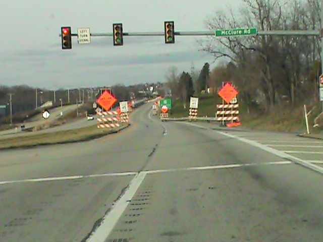 |
| road signs at McClure-there will be much more in the future! |
 |
| Sherrick Run east of Rt 119 road work |
There were the Emma and Bessemer coke ovens nearby to Sherrick Run and possibly the route of alternate historically important roads. As was normal in this region, there existed various mining operations some of which were owned by the Overholts. I personally know of an Overholt gravestone near here. Even more roadwork would surely make further identification of the paths of either the 'TFR or the Old Braddock Road difficult to discern.
It is to be admitted, even without the additionally planned road construction for the future identification would be a difficulty, but at the least, a definite possibility. (Please do read the link provided and see for yourself the Barker Map route). There is reason to believe the Turkey Foot Road had a branch running just to the northwest, possibly nearer to Sherrick Run, fairly close to the placement of the Old Braddock Road. The last is very different than the known route Braddock took from near Everson on past Prittstown to Hammondville, then heading north and crossing Jacobs Creek and meandering up through Mt. Pleasant.

This photo is looking toward the west where Cherry Hill is located roughly 2/3 of a mile away. Backed up traffic above - a regular sight.
 |
| Sherrick Run north of Iron Bridge |
The Turkey Path Road: A Connecting Link
 |
| The Turkey Path Road to the northwest |
This photo shows an area very near the nearly finished Rt. 819 road construction where some believe this old back road superseded the route of the modern one through Scottdale and Mt. Pleasant so being the earliest road to Mt. Pleasant. Keep in mind, the dirt road is well placed in a directional manner indicating a route from and to Cherry Hill where it once had a bridge abutment where it meets the 119 four lane today, crossing Sherrick Run on to join the Old 119 road through Pennsville.
Interestingly the old road itself has been known since time immemorial as the 'Turkey Path Road'. Is this a possible, even presumable, misnomer referring as much or more to a small piece of the Turkey Foot Road itself instigated by George Washington? The consideration lies in this small, apparently insignificant road local tradition claims was in old time used for the driving of turkeys to market. Speculation only, as the answer is not known at the present.
Nevertheless, the relation of the two is an intriguing consideration, is it not? In point of fact, this IS the specific area of placement where it is quite possible, and in my view a fairly probable hypothesis, the Turkey Foot Road was laid by Providence Mounts and his men toward Cherry Hill, once called Alice in its mining heyday.
Not long ago, Lannie Dietle discovered a tract of land near Cherry Hill which places the Turkey Foot Road routing through there while another tract from an old survey clearly proves it led from there to outside Ruffsdale and headed on to Hunker, meeting up with the Braddock Road. A valuable contribution to the matter at hand, and I would hasten to add, to history in general.
On top of this research, originating from the south, near the Dexter Road is an enigma of what appears to be a stone road and very old bridge without the use of mortar which indeed still exists. It really needs to be seen to be believed! The total significance of my discovery of this structure is yet to be perfectly understood. Well, deriving an approach which may well of ran in two branches in a basic western and then northern direction - one from the old Spaugy Mill in Wooddale, the other from the Country Club area, both in Bullskin Township, the potential of this area and the worry of the proposed roadwork should speak for itself.
As for the Braddock Road, I've briefly mentioned something related to it and the 'TFR' in a recent post on Various Inquiries at the start of the year immediately under the header 'Some Upcoming Posts For 2016'. To repeat with more detail and flesh this out, there is an old tradition (certainly favored by the rather eccentric Indian artifact collector Dwaine Fuoss) supporting the notion that the colonial regulars of Braddock's Army crossed the Youghiogheny River above Connellsville at Broadford. They most assuredly were on the march to an ignominious defeat at the hands of the French and Indians. That doesn't fault the amazing ancient roadwork of blazing this wondrous trail through a deep wilderness or discount the little known but great enseavor of creating the Turkey Foot Road some years later. Now, supposedly according to these traditions the crossing was not at Stewart's Crossing to the east as is normally understood by most historians. Instead, this route would have taken them through Owensdale and it is said, the group crossed Jacobs Creek at Stauffer's sawmill near the modern bridge that crosses the stream today on Dexter Road. The remnants of the sawmill can still be seen. The road exits Fayette County there and leads to West Overton Village in East Huntingdon Township in Westmoreland County north of Kingview. Interestingly there is another tradition that the Turkey Foot Road also was routed a mile below the Iron Bridge very near the modern bridge as well. Such considerations allows for thoughtful introspection of these possible routes and differing theories.
For those visitors that are not aware of the depth of my studies, there is more material on the Braddock Road route located on the post, 'The Braddock and Turkey Foot Roads Near Walnut Hill with added Information.'
While modern roadwork has been an ongoing and often necessary reality since the days of the railroads and even long before those times, a serious caution needs to be raised against modern 'improvements' under circumstances in special instances. I expect this has been better studied in this post. The inquiry of Penn DOT's historian lends some relief as does show their appreciation over historical matters when it comes to the performance of their duties.
The danger of the possibility of damaging truly historical parts of our momentous past, particularly in this region as I understand it, is compounded by the apparent route of what was termed 'The Old Braddock Road' on the 1857 Barker Map bordering the Upper Tyrone and Bullskin townships and on to the Mt. Pleasant and Hempfield townships. Coincidentally, this place surrounds Iron Bridge which I have done two articles on to date. Here and here. Although the apparent alternate route of the Old BR does appear to be just to the east of Sherrick Run and near to the Pennsville Mt. Pleasant Road, yet the route of the Turkey Foot Road, if indeed it was through this area, as is likely from various descriptions. In my opinion, it is unknown and not shown any map what exact ground was covered in the process. This is a bit too close for comfort to traditional routes of these two important historic roads in our region to take these chances So, it is agreed with knowledgeable citizens such as Jay Stern for a good example and others, 'we' are slowly but surely destroying any further evidence leading to any additional discoveries in the future. The statement might not need to be made, this is a sad indictment of our society.
Summation
We have a call out to all those with a quality background in our history specifically and the many members of our community in general who are interested in our local heritage.
I realize the humble efforts of a lone stand on this issue must be tempered with the practicality of valuable time and resources available which might appear on the surface to leave at a minimum the amount of cooperation issues like these require for many persons and organizations in the Laurel Highlands, far and wide. Such is to be expected to an extent of course. This is hardly an acceptable or proper excuse for the alternative to simply leave things as they are going; pursuing the regular course of events for the sake of constant progress and expensive costs, however the situation seems justified on a superficial note. It is clearly debatable if the construction is even an actual necessity or wanted on a practical level in such an economically strapped community. Do take a closer look.
The type of situation documented above should, frankly, be nothing less than a Red Flag to those in charge of our commonwealth near us, especially on the state and local levels, to further their fine cooperation and temporarily set aside for a small time the normal operations of the work they do in many arenas to show a deeper interest in these matters.
Let's Get Involved in some manner. How does that sound? Take a moment, do your own research before it may be too late to take any action. Decide if this issue is important. Find out what can be done and become more educated about the loss of our historical roots. Decide for yourselves to learn more of the significant amount of substantial gems and features of our landscape that have been already preserved and protected. Please follow the links provided and read up on some of the intriguing discoveries and recent studies that shine a brighter light on the ancient roadways, buildings and personages of our past. You may contact PENN DOT and voice your own concerns, as well as join in with the local historical societies and tourism boards. Give your opinions, undertake meaningful discussions and help garner support.
As for the historical realities and suppositions I recounted in this article, it was an enjoyable experience and well worth it to go back over much material dealt with in the past few years that although well tread, has shown surprising new research considerations and exciting vistas to connect the past to our present times.
Thank you for your patronage of this blog and the move to conserve more of our unique historical associations in this region !
Have a blessed and Happy Easter everyone!~ histbuffer