I hope the last article on my uncles from World War Two captivated some of your attention. Although, it can be a tough thing to write about, I am glad to be able to do something to honor their precious memory. By the page views here, this is such a satisfying reward to see the renewed interest.
Contacts
I suppose it evenually happens to everyone that blogs for a living, or just keeps a website as a part time hobby. This may be a difficult topic to approach wholeheartedly, or even half-heartedly. A glimpse into a brief, though troubling relationship doesn't have to be too painful and should hold enlightenment to a certain future reference. Just getting something off my chest. You've been forewarned. By the way, nothing said here relates to anyone I am in collaboration with to any extent in the present. You are ever so appreciated!
Contacts can be developed over months and years in varying ways. I might meet someone out of the blue, right on the street. That isn't usually my experience. People are able to really surprise with enthusiasm from time to time. Distant relatives become interested, maybe a little critical, or old friends seldom heard from and little seen, offer a word of advice. An off hand e-mail, an acquaintance on Social Media, a follower or subscriber, or someone you love subscribing to. A friend's friend on Facebook, whatever. I've only made so many close contacts, and maybe this is for the best, and then, those sincere individuals that truly care about someone's website are surely worth developing an association with. There can be a world of collaborators and colleagues open up a virtual door, with all this entails:
1: You talk to new contacts with much in common. Some can become so close and in frequent communication that you bring them in, perhaps through needed expertise and valued help in different areas, to the level of co-administrator.
2: You sometimes find out just how little you have in common with a broad group of slightly interested folk. Sometimes.
3: E-mails come tumbling in at an alarming rate, (many of us would only wish this was true, while some would give their lucky stars they would Leave Them Alone!)
4: A few turn into valuable friendships, knowledgeable collaborators, and even competitive colleagues and alter egos.
Whatever the situation or reasons, occasionally, there exist those personalities which, not only may clash, but perhaps become enamored of our purpose or goals, often a gratifying relationship we would hope to repay in some form, some day. I am not talking about romantic ties here. More rarely, there are some guys and gals vaguely and also very aggressively intrigued with US, ourselves and every darn thing about our lives. Eh? Where you feel like pulling your hair out, or it could be, theirs? No?!
Next, is the sticky, albeit sometimes theoretical situation, and thankfully, a rare one for most.
A Dreaded Situation
The colleague who sort of insinuates his or herself through the benign aspect of volunteerism. Maybe you are close friends, making the relationship is all the more meaningful...and DIFFICULT to extract yourself! And maybe through no fault of their own, make serious inroads on your time and abilities. Energy drainers, wasps, backbiters, right out of the New Testament, for all to avoid. BUT, you sure didn't ask for this situation? Did you? Too polite with a large helping of guilt toward someone who holds out a hand in our direction; sometimes they are well seasoned pro's at noticing every whim, calculating reactions, marking it on a mental notepad. Not entirely a facetious description. One just might want their input, mailings, moderation, time? Oh my, yes. Conversely, one might rather be left alone. Rarely, there are those, usually supervisors or bosses, that so in fact test us, sure, but some will strip you of irritating responsibility and perform everything for you! A small case of paranoia finds inevitable existence in reality. Often no serious, permanent damage is done. In other extreme cases involve stalking, late night phone calls, bothering your girlfriend, drinking your last beer, that sort of thing. Software info, sometimes their own brand, a mere coincidence, rest assured. Changes in format, oh very helpful at first! At the worst they can wreck havoc to the rafters! Innovators. Attempt sudden DMCA's; stealing your prized material, re-publishing it on mirror blogs at the speed of light, Forums. boards that are quite impressed with this new found knowledge, anything they can do to shut you down and disown you. Then, slur you as the interloping charlatan. 'TAKE OVERS'. A dreaded nightmare experience, I'm sure. Luckily, I haven't been a victim of that brand of hell and hope I never am.
One fine day, a well mannered friendly associate. The next, fangs and riveting attacks, unveiling your most private thoughts; reveling in evil and destruction years on end. Gosh, they claim these things happen on a frequent basis for some unfortunates. We hide our faces from it. Or, delectably look with eagerness for all the dirt. So they say, anyway. Shew! OK, calm down, start a new site, move to India or Costa Rica, wear a disguise and pray they will go away!
The type of colleague I am referring to is more mundane. Yes, somewhere in the middle. A blessedly briefer encounter altogether. At first, this was interesting and a nice relationship. A person well off and instructive, knowing the region, though not living there since he was young. H'mmm, can you see where this is headed? Well, so many of you are intelligent, smart, perceptive, I know this.
Chock Up One Experience For The Blog
The gentleman was in business for himself; a wonderful thing, an entrepreneur. In the midst of a breezy chat that ran on for hours, (our first, and really only, phone conversation), the discussion ranged from personal hablits, to the old and unique bridge structure in the Upper Tyrone and East Huntingdon at Jacobs Creek., a real enigma still desperately in need of further attention on a professional platform; and discussing the likely connecting route of the Turkey Foot Road which Rodney Mosler, among others, claimed to of headed through this almost exact location. Someone that saw the situation the same as I, ah, a conversation worth its salt. Now coming across even more excited by the discovery of the old bridge at Dexter, to the realm of obsession, (I thought that was my job?). He then suddenly began diverting the talk into giving these odd, lengthy examples of his experiences helping people, that just didn't work out! Amish people, Florida Everglades, no he wasn't selling me land for religious purposes down under, but possibly his connections to software companies to help UPGRADE my life! Maybe this was only the nuance given, if so, never mind such outbursts. Nevertheless, I was bordering on a migraine and rather confused by now. Well, the fine idea of changing my website, turn it into something else, private hosting of the finest variety, indeed, magnificent chap. SELL YOURSELF. Well, off we go!
But wait, I'm getting a bit ahead of myself. There I am, wondering on end about this internet avenue, and he did infer helpful suggestions. Really. A better quality camera, why, of course, I will happily pay for this, no problem, who else? (Which I recently did. It wasn't as very expensive as it could of been and works fine so far). Next up, form a non- profit; intriguing concept which I am out of my element as to why and how. Many of you may know more of this than I, a bumpkin with a bare bones site, missing a few teeth, that when I am taking it easy some days, lounge around in pajamas. A slightly lazy guy with only a measly internet presence of some credible value to keep him near reality and from the abyss of absolute insanity. OK, I am exaggerating; just the last part. Oh, you figured that out already? Good. Well, the video idea is fair too, but unless we're on a train, a boat, thrashing through the jungles of forest, it can be almost the same benign experience in our Southwestern Pennsylvania counties, the moving images, awing explicit dialogue, adroitly catching yourself swearing at bugs, mumbling and saying 'ah three times in every sentence. Demanding, in depth docudramas can be a bit out of my range with my brand of regional history, as a digital camera with photos seems to usually do the trick. I'm befuddled now how this was managed! But you must use your imagination here. You know, back water, swamps, moonshine and all that; undershirts, no shoes, hiccuping and snoring the day away with fitful dreams of a normal existence like regular, city folk. Such horrid intimations might arise in your psyche. Dreadful. Reminds me of reality T. V. Too much imagination.
Alright, this is hardly proper, pulling your leg like this. (I do live very close to a city,and I go there once in a while-honest!).
As a footnote, the point remains, a few of these ideas were sensible and proper. 80 to 90%, in fact. I am in the process of sorting some of this out. He told me to 'mull it over', maybe for a few hours or a day at best I was to discover, was the ordered and planned time frame. Where was my choice in the matter, you ask with baited breath? Non-existent son, eat your oatmeal, it's good fer ya! The heck with them there hanger on types. Forget their help and guidance, any usefulness. You don't need THEM anymore boy, you got ME! Upscale to the penthouse. Do I exaggerate, maybe a mite, or two. Well, the bottom line is that I was apparently expected me to integrate the idea by The Next Day and jump into this immediately, or I may well be some kind of traitor or renegade type. Maybe the problem was in the delivery, the pitch I heard. The last word of ADVICE was to chuck my friends, eliminate colleagues, disavow all collaboration, or something to that effect. It was rather a shocking explanation to better myself in today's competitive and cut throat market. Well, the world can be tough place I guess, this line of thinking could be, why not become like those people? I found this upsetting. Looking at it one way, why allow an outlet in myself for an express ticket for a turncoat and hypocrite to anything I stand for? Yea, maybe no big deal, we're off to the limelight in Tartarus. Do a selfie and grin broadly while deleting many e-mails. So, I am using an analogy bordering on exaggeration. It IS partly, but you understand. Am I correct in this assumption? Come on, this is a totally about face experiment to entertain while providing a basis in sheer fact and dwelling on the importance of my next historical post. Something to avoid, and another to enjoy.
Now, when I didn't call exactly as planned, a few mundane things took place. Well, I called later the next day. Yikes! He was...standoffish, temperamental...moody; 'I don't really feel like talking about this subject right now', he mumbled through his presumably gold teeth and expensive caviar and wine. Just joking there, of course. I had visitors in the room that could hear what was going down. Not dumb people, unbelieving the tone of the turn around in the conversation, just the same. He left off the phone a while and came back, he then stated, dryly, he doesn't want to discuss any of this... bye...so bloody offended. The very idea I would mull it over a bit longer, as I had been kindly told to do, must of been forgotten and abandoned. Ponder on the details conveniently left out. What can I say on my behalf, I'm just a rebellious fool at heart, aren't we all sometimes. Or, so I was made to feel. That was that. Game over. The real clicker that echoes back to me, is that he stated, "I could probably do this kind of thing myself"...h'mmm, heard that voiced before. Then the thought arises, and why not?
Well, I did respond to his last e-mail which stated in no uncertain terms, his 'intuition' told him I am not truly supportive of changes and this heady assistance as a volunteer in my internet army might not be required, or something near to that effect. I guess that makes a wastrel, a slovenly lackluster dude. A very harsh idea came to me that a self promoted, high class General would obviously not appeal to my better judgement. Where was this going anyway? Someone breathing enviously over your shoulder with constant opinions is not always a tell tale gift from Heaven. Yes, I am weak and desired to get the last word in, by God! Writing back of my comprehension of the whole doggone situation, but, of this e-mail, although severely tempted, I will do as a genuine colleague has seriously advised, and take the high road. I know, some of you might of relished in it. I admit to that very emotion. (Maybe you could e-mail me privately, oh, alright, never mind).
To this day, the bottom line is, I feel an odd sort of cold sympathy, mixed with bemusement and an opportunity lost that was hardly expected, or desired. I had a bout of depression for a few days, later turning to a philosophical stance. The situation could of been something meaningful, but temperament can get the better of people, no matter how educated or fascinated they are, leading brazenly to such a gun ho attitude in one that, originally, might of been as simple as an overzealous offer of some needed help. I can handle what most dish out. A choice, sure. But, really, why NOT think it over? The guilt could be mine to be shared in being a little too sensitive in my approach or outlook, while the example above is just one of those things, and I do wish this person well wherever his further interests lie. As long as it isn't involving me.
No more lectures on this lamentable subject. Colleagues and friends can be an important part of our work, play and all facets of our interactions in any field, in our busy moments and the quiet hours. We might want to reflect and be thankful to those that are there for us, and likewise. I know this isn't brain surgery, and I am of no perfect example, only drawing out one unfortunate obstinacy experienced. Many of you good folks come from all kinds of backgrounds, ages and capabilities, are discerning, intelligent and, mainly, well adjusted. Life has it's peaks and valleys, isn't that the truth? Whether we ever grow comfortable with the colorful aspects that contain a few thorns, that can lean toward the white and the dark, such things we either overcome, or struggle with. Hopefully, most dealings are a balm to the soul, wishing my visitors well intentioned connections, keeping the feelings of those closest to you throughout your lives, as one's dearest possessions are sometimes the least seen and felt.
Speaking of bridges, I will have an update soon on one that is not at all lost, the Iron Bridge. Keep checking back and it will be published in time. Thanks so much for your interest! Please take a look at the other posts and check in again soon!
Showing posts with label lost bridge. Show all posts
Showing posts with label lost bridge. Show all posts
Saturday, June 13, 2015

Thursday, November 20, 2014
NEWSFLASH: A Very Old Bridge Just Discovered!!!
Introduction
Hello, history buffs! YES, a Newsflash is a fair description what is being related below.
I confess to resembling a bulldog, but only in habit. On the trail, sniffing away, chasing things around. When I am on the scent of unique significant items, there is no let up, hardly time to eat or sleep. And this time, ladies and gentlemen, I struck pay dirt!
Scroll down to see the many photos I captured here near Dexter.
Not long ago, I made a unique discovery! Just how important over all, remains to be decided. Maybe it's the hand of fate, or I simply got lucky. I do not claim to be knowledgeable on every aspect of the subject, but a very excited amateur historian who happens to run a regional history website. This is a fairly sudden experience, and was hurriedly undertaken, as I desire for my visitors to learn of this remarkable structure first! This is the type of object that has the adrenaline pumping. You will want to read on and understand this for yourselves.
Coincidentally, I was exploring this area for an upcoming post on Kingview, and the Stauffer family. Now that must wait on a back burner. A similar post was being created in preparation for the West Overton area and the Overholts and H. C. Frick. Having so many irons in the fire proves one thing- I am keeping busy! Further information constituting the exact meaning of what was found at this place might yet become available as extenuating research, and will be added as need be. I have been deeply concerned with the task of other important posts lately and working much overtime on the job. This is a bit rushed. Any noticeable errors will soon be promptly corrected, warts and all.
NOTE:
Whether this was a definite extension of the Turkey Foot Road, hopefully, time will tell, though it appears there is some evidence provided by Jeff Hann that there might of been a R x R spur from the PA railroad to the north running to the south and the Monongehala R x R ran through the area. This is almost precisely where the 'elevated road' is located. The difficulty arises that this is also where it is conjectured the Turkey Foot Road extended into East Huntingdon in Westmoreland County, on its course to Mount Pleasant. This would make gathering further evidence difficult.
It has also been brought to my attention that this old bridge and elevated path might be considered to be only the old road to McClure and the Diamond Mines, down from the Dexter Mines, and probably nothing more. I relish the chance to put this to rest, and it is constructive for this post that the issue was raised.
The McClure road led to the trolley station to the north of Jacob's Creek, where I have photos of the remnants of a very different type of bridge that crossed Jacob's Creek, made of concrete on the Iron Bridge article, "The Meeting Of The Townships", and some mentally sharp old timers made recent claims that it was used to go to catch the trolley, or street car there. (The names can be provided, if necessary). I haven't located a definitive map that includes this stone bridge near Dexter. Therefore, I entertain some doubts of any such theory.
The stone blocks of this bridge, some of which appear roughly cut, do strengthen the case of it's vintage age. And I have observed the McClure bridge on one map, and as the McClure bridge was clearly still in existence at least by 1939, the year the overhead black and white photo was taken, and, I believe this is on later photos, but must check to be sure. Lastly, these people are in their 80's, so the recollections do substantiate the placement, direction and use of that road and compliments my contrasting view by the age of the photo of the McClure bridge.
Below is a schematic representation of the above statement (click to enlarge):
Basic Background and Orientation
A little background is certainly in order. The Glade Path, or Pike from the east and what became Route 31, with Bouquet's route or Forbes' Road; The National Pike and aligning with much of Route 40; and the Ohio Company's and Braddock's roads, from the southeast were the first roads in our region beyond the confines of the Indian paths.
With alternate route and branches in key areas, there was also what was termed. the Turkey Foot Road. Now, this was first cut and travelled, most likely by horse packers and traders, and then slowly improved for wagons and coaches starting in the early days of the mid-1700's on through the 1780's, 90's, and as the Ohio Company got involved in intrepid pursuit of road making in a parallel area, changes were made in the branches and routes varying here and there. The term originates from the appearance of a 'turkey foot' at Confluence, on the very border of Somerset County, basically from the south as the crow flies. The Laurel Hill Creek, Casselman River and the Youghiogheny flow through this old place known for it's Indians and the Sloane Ford. (You will find a few photos of this at Confluence I provided in Mr. Dietle's excellent DVD that is included with his book).
These approximate directions can only be applied as spokes from the general border region of Westmoreland and Fayette counties. Of course, when observing a map from other places and states, you will adjust your position, accordingly.
Granted, there are more early traditions that survived connected with the Turkey Foot Road due southeast toward Somerset County, with evidence of early Indian trails that were slowly cut and used by the white man for pack horses and eventually cleared for wagon routes.
More knowledge has also survived concerning many of the Indian and trader towns further north near Pittsburgh and to the north and east toward the Susquehanna, Genesee area, Bedford and Lancaster. Much has been documented in Maryland, near particular and conspicuous places. This is a relatively neglected area in Fayette County; economically and to an extent, historically. There is some reason to conclude this road system was abandoned early with the creation of the 'chain bridge' on what is termed "old Rt. 119". Less tradition remains here compared to the more rural places like Jones Mill and Mill Run, etc., where the Springfield Pike, once known as the Clay or Mud Pike, was one of the main thoroughfares off the mountain to Connellsville.
As I have been presenting here for a year, Westmoreland, as well as Fayette, have a rich past as proud and influential as most any in the nation, bordering on the gateway to the Northwest generally, and the Ohio Valley more specifically. More investigation is needed to dig down to deeper layers, and this endeavor is worth every effort. The hunting ground of the Seneca and the watery routes to the Mississippi River. A land of boundary disputes, fueled with Scotch moonshine and tempered with the admiring land surveys and excursions of our first President, no less. All this and surrounded by great states as well, Virginia, New York, the mounds of Ohio, West Virginia, Maryland.
It appears likely that a R x R track once ran through the area of the elevated road.
There is a fair amount of railroad and coke oven historical knowledge available in our region, to the degree that this hasn't been examined as heavily on this site. That may change in time, but I do concentrate on the oldest material I can reach when this appears pertinent. I feel that is partly the case in this situation.
Recent Posts With LINKS About This Subject
Instead of unnecessarily repeating myself with material from former posts, (SEO and Google can be a bit unforgiving for doing just that), I will gladly link you up with further information. Visitors will be well advised to check the February guest blog post of the author of "In Search Of The Turkey Foot Road", Lannie Dietle. I have had the privilege to collaborate with him. So much the better, in fact, for here is an exclusive interview on this very website that I also conducted with Mr. Dietle in September. This would be a good start for those who want to learn more of this subject. His website is referred to on these posts as well.
ALSO, when you can, please check the post I uploaded on October 20, "The Braddock and Turkey Foot Roads", and from October 7, "The Lost Cemetery On The Braddock Road." These two articles will help clue you in for a broader scope of background information leading up to this post. Having said that, I don't envisage myself as any kind of expert on the Braddock and Turkey Foot Roads. Rather, my research encompasses and associates freely to the extent when it is encountered.
I have made mention recently of this older layer of history. Forgive me if I make any repeated statements again, I'll try not to continually do so in the future, but it is hard to completely avoid. Over the months of combing old and newer books and recent research and such, looking in dim realms catching snatches of this or that, I learned more of many things, branching out into the very paths of comparative history, literal and figurative, to the very places often described here. So, from a minor chronicler of regional hamlets and musty archives, I felt myself transformed into a bit of an Indiana Jones for a day. This was accomplished simply by digging around Jacob's Creek for a few hundred yards. I would add this area near to East Huntingdon was not posted when the photos were taken.
Research and Synopsis
I want to include a look at the old warrantee surveys for this region of Upper Tyrone township:

Frankly, I never dreamed of bing enabled to make a valuable contibution to the region. One subject earnestly delved into between blog posts, would be humbly, and sometimes closely, studying those that have been there with a broader brush and larger canvas while maintaining a semiautonomous position. Lannie Dietle comes swiftly to mind as the most recent of a long brilliant line, especially when we are talking of precise details and disciplined scholarship. He and his team's excellent and laborious work on this fascinating subject helped guide my instincts on one side, as time went on. I also felt curiosity toward the details of the historical underpinnings of the Braddock Road. The specific function and course have been plotted out in the past in many areas already.
At the same time, I will be quick to point out, I make a habit not to limit my curiosity because of other influences. Independence can be a lonely thing. One advantage it holds is in keeping a clarity of self reliance necessary to form your own opinions and stand on your own two feet. For instance, I've included recent articles on the Braddock and Turkey Foot Road in October on the website where I struck off on my own a bit. Maybe I am sticking my neck out here farther than is usual.
Admittedly, my main venue of research had naturally enough retained it's focus on the Westmoreland and Fayette County corridors and townships of this region's great addition to those days of awesome power struggles and stories of the French and Indian War, Pontiac's Rebellion, the Revolutionary days and the Whiskey Insurrection, to the coal and coke days, the railroads and into the 20th Century, and beyond. A natural progression. Nearby, were the expeditions of Trent and Burd, a glimmer of the presence of Daniel Boone; explorations and missions of a young George Washington. On my website are included some of my own ancestral material that is meaningful as it relates to certain aspects of local areas. I will be updating this in upcoming months.
On the northerly route where the Turkey Foot Road crossed over the Chestnut Ridge, we find less to go on, only in old deeds and vague traces do we find a hint of the path. Nonetheless, we know from Washington's journals and many tidbits of historically significant and valuable writings that the roadways were much built and improved with military guidance with the trader and settler activity.
Providence Mounts, of whom Mount's Creek was named, was one of the main protagonists associated with the northern branch of this "TFR". He and his name sake lived at Connellsville, in what once Bullskin Township, before the family traveled on and into the Kentucky territory of Daniel Boone and other early pioneers. During the Revolutionary War era he was given charge in this lengthy process by orders of Colonel Morgan, passed down the chain of command from General Nathaniel Greene, as advised by no other than George Washington. So he did much to develop one of the original roads in this broad region of rivers, swamps and mountains. A truly amazing achievement. This led to the successful northern campaigns of Brodhead and Sullivan against the British and Indians. It began at Cumberland as a military supply route, traversing parts of Maryland generally to the northwest and heading northerly into Somerset County and northwest to Fayette County of the State of Pennsylvania, in some ways rivaling the Braddock, or Washington Road and Bouquet's more northerly route of Forbes' Road. The route came through the mountains to Mill Run and Normalville and entering Wooddale via Hawk and Quail antecedents to the northwest. It ended at what was then, Fort Pitt. This road was much used by settlers to these counties, at least until the early years of the nineteenth century when with congressional approval, the National Road was put into effect and created. With the creation of the railroads, these thoroughfares took a back seat for many years until the days of the automobile. The bustling stage coach and wagon stands and noisy taverns saw little traffic and were slowly closed down.
True, there are a few people of particular importance that weren't immediately filled in on this post. To you, I'm sorry this find had to be sprung it on you in this way. For better or worse, this was certainly meant as a surprise and called for a quick release. I personally am partial to surprises and this is an early Christmas gift!
Again, the structural photos and location are released publicly because I received such swift responses for the request of experts in the field from The Pennsylvania Historical Museum Commission. They have a great site with the state archives and early documents. Also the Fayette County Historical Society. The involvement from those interested parties can be crucial to advancing this research. This is their pony show, and their due, if only they take advantage of it.
I can surely use all the support I can muster. This is your history folks, and your region!
Those of you who desire to become more directly a part of this fascinating find by sharing your own interest in this research, by all means, do pass on your stories and local knowledge by writing the above organizations in charge of the history of the state of Pennsylvania. Anyone with more info of this location can also leave a comment here, or you can e-mail me, (you'll find both contact forms below).
Directions And A Hint Of Another Post Soon To Come
The location of this old structure can be reached from Mt. Pleasant easiest by exiting US Rt. 119 south at the Scottdale exit, turning right on 819, and after a mile, make a left at West Overton on Overton Drive. After passing a stop sign you will cross the old street car track and come to Dexter bridge and the PA railroad with the old saw mill to the right. It is to the left down Jacob's Creek and the tracks for about 100 yards. It is 6.4 miles from Connellsville where from Rt. 119 north, you will take the next exit past the Everson exit to the left at the stop light, up Walnut Hill and down into the Kingview valley, making the next right to Dexter Road. This will lead you to the train tracks and the location is to the right after traversing a small steep hill. The basic coordinates adjusted for online searches are 40.106458, -79.570136.
With the recent work of Jeff Hann of Bullskin on the area of the TFR up near Quail HIll Road toward the intersection of Spruce Hollow Road and Breakneck Road in Bullskin Township, I too, had the opportunity to walk an historic branch that is surely closely connected with the Turkey Foot Road. Mr. Hann was responsible for bringing this find into the realm of documentation and making contact with the website by e-mail.
Truly his contribution is such a bonus. And with guidance lent from Lannie Dietle, (who is including the information as an addendum to the fourth edition of his book), will very soon be covered in detail on this website. and hopefully, elsewhere.
Over the mountains this road was cut from the Normalville area to Hawk Road and on toward the Quail Hill Road area where you find Shultz Lane near the old Smith surveys. Here where there appear to be traces and evidence od the roadbeds were recently visibly discovered, the basic road is estimated from the year 1794. Running on to Shenandoah Road, where my great, great grandfather happened to place his residence, theoretically, it moved through the hilly draw toward the Gault School Road to where the old trace had crossed Mount's Creek at what last went by the moniker of Spaugy's Milll as was the old road name there near where my grandfather lived. The oldest name for this mill was Cathcart's. From there the Turkey Foot Road meandered on a course to Jacob's Creek, bypassing the Braddock Road to the northeast, yet crossing it for an apparently easier, dryer route and on toward the north and the Mount Pleasant area. This specific research would hardly of been possible without the knowledge given previously of, "In Search Of The Turkey Foot Road' to prod me to make my find a reality.
I began this specific search while finding extra hours to check this out and the more interesting this became. Here on the borders of these townships, a part of another road that vanished that once traveled down Walnut Hill from the south, and yet another road, wending it's mysterious way up Walnut Hill from the east. This is where I concluded one would of crossed the other before meeting up later. Traditionally, the Turkey Foot Road headed into Westmoreland County on a different route. From a 1939 survey of black and white photos and consulting old maps, there is some substantial traditions on the edge of what was Tyrone township. From the south near Everson and the Bullskin, Upper Tyrone township line, arriving from the Wooddale area, the two routes meet. Here, in what is now such a hamlet that is deceptively normal, was a secret piece of the Braddock Road, and a very likely route of the Turkey Foot Road.
Fieldwork With A Caution
So, thank God, I decided to walk through the bramble and thorns of centuries. A player, and no longer just an observer. Taking a closer look at this surprising region of the deep Connellsville Coal Fields, with it's multi-layered historical tapestry marred by much of the very subject it was an historical part of. Too much history! Imagine the irony. To the point that anything beyond the train tracks and strip mines is difficult, nay, practically impossible to fathom.
Here I believe I got lucky, and at the same time, downright nosy. Impetuously, I simply determined to search out what I could with little thought of what waited hidden. With this discovery, or possibly, re-discovery, though it would be an unpopular decision, I was adamant to not IMMEDIATELY divulge all the details of the exact location UNTIL proper authorities were informed and brought to the knowledge of it. That was the position taken.
The above is adjusted slightly from what I wrote a few days ago, before gaining some assurances from the proper authorities this will, indeed, be investigated further. As I am satisfied to of gained more interest, I am happy to get this off my chest in revealing the whereabouts of this old stone bridge and wall remnant that lurked under our very feet all along. So very close, but buried for many years. Neglected, lost and unacknowledged.
Here is a cropped 1902 topographical map of the region:
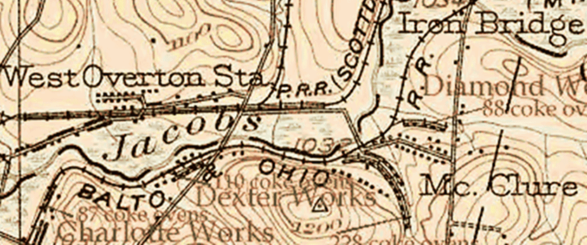
As much as could be ascertained, the old bridge was languishing, completely forgotten, as if caught in a time warp, and had never existed. Though there was some cut stone work in the late 1800's, and depression era, such as the Cunningham bridge remnants near Creek Hills that had concrete abutments, and obvious stone block supports on BOTH sides of Jacob's Creek, this structure certainly has little appearance of modernization connected with it's origins. The angle of the projected crossing is somewhat unique as well. The fording area has a similarity to the Sloan Ford crossing at Confluence in my opinion. But, as I stated, this requires more careful verification, and possibly, excavation.
So I stepped toward legend and found a bridge to the past. Literally.
Eureka!
Do you see any hint of mortar or concrete? I do not.
A Few Speculations
From our way of peceiving what is valuable, this is better than gold or silver. The old saying is appropriate here, "I was in the right place at the right time."
This does give you folks a good idea of what might well be right around the bend, and ,as often stated, 'down the road.' Who knows what else can be found? So, keep your eyes wide open and when something looks old and neglected in your neighborhood do try to check it out. The ideas that ran quickly through my head. DO you want to be privy to my thoughts? I wondered if my parents guided me to this place to finalize a category of old history that had entranced and obsessed me to no end for months and months. Ask anyone that knows me personally at how consumed I was with the varying levels of our local history, and they would be sure to confirm this is no exaggeration. Or, this was simply facilitated by a chance encounter on a small excursion, and that was that. The mysterious moving of what we call chance, fate and luck do occasionally give a more than casual entrance into and out of our lives from a rarefied viewpoint. Regardless of these random musings, I am satisfied in the sense that my late night readings with old books off and on for the archaic space of forty years and collaborative involvement with others of like mind, with the aim of this fairly new website, led indirectly to this investigation.
I ask, does this have the appearance of a railroad spur? No mortar or concrete here. You can decide.
One thing I can relate with some confidence, concerns Mr. Rob Doolittle of the CSX in Fayette County, who informed me, in response to my inquiries on the subject, that he has no evidence of B&O involvement with this structure from the property department archives. That research is highly appreciated.
What Is Here Documented:
Much might be conjectured and realized over time about the usages of our Jacob's Creek site. What we can document with alacrity and assurance is this: an old partially crumbling, stone bridge exists at the location. The noticeable crossing alignment. The fording area without a hint of stonework. The relatively small size of the blocks used. The lack of observable pylons or stumps as in other places near here. The interfering elements of railroads and mining operations, saw mills and coke ovens. The tight fitting stone wall. The elevated road, possibly from the West Overton area, but likely from the 'Mon' railroad which somehow passed through parts of what contained swampy places. Quite a feat of engineering. And the absence of mortar. It should only require stating this once, all will agree, what the bridge and wall unquestionably are not, are hypotheses, theories, or probabilities. Whatever their exact interpretation in the historical record, they are there to ponder.
Old Historians
As was prominently claimed for this area of Jacob's Creek, this is presumably very near where Judge Veech said the Turkey Foot Road crossed Jacob's Creek "about a mile below the chain bridge", (Iron Bridge), and a few others made similar claims, are the cut stones of a bygone age, where they were partly uprooted by trees and falling into the stream bed. Franlin Ellis on page 756 of his book, "The History Of Fayette County", when referring to the route of the TFR states, "...it bore to the northwest across Chestnut Ridge to Mountz' Creek, which was crossed at Andrew's, (now Long's mill); then northwest across Bullskin to Jacob's Creek, in Tyrone, intersecting Braddock's Road near the old chain bridge." The coincidence, if you could call it that, is very striking indeed. This must be taken seriously as circumstantial evidence presents itself.
Though, it is doubtful the elevated road is older than the railroad tracks as this is not the sunken type one would expect, past the B&O, now CSX tracks to the creek named after Captain Jacob's, a Delaware Indian chief, I indicate that this might follow part of the TFR. On the other side one can see a road continuing toward the northeast, where it seems to lose focus in the undergrowth. As this appears to be part of what was the Monongehala R x R, again, this would seriously damages traces or scars of the old road, projected to run to the northeast and west of the Y pond region where the Southwest railroad crossed Sherrick Run beside what is today the Coal and Coke bridge to Iron Bridge. This does not destroy the idea of former use. The Pennsylvania Railroad apparently leased the West Overton tracks, but as to the particular significance of this in relation to the age of the bridge, I remain skeptical. There is an impressive old stone wall that I am not expert enough to do more than contemplate about it's age and use. It might be a retaining wall. As of now, the function is not known.
It is possible many of the bridge stones were removed on the Westmoreland side, if there ever were any in the first place, but this is unconfirmed. Again, it is to be kept in mind the elevated East Huntingdon township road may not be directly connected to the bridge and where it crossed. As near as I could ascertain, the stone bridge road on the Fayette side is, approximately, 20 to 25 yards of stone blocks. This is not a large width or huge blocks usually associated with a railroad which suggests an earlier verson may lie near here or under this bridge.
The structure may of been used for other purposes, which is always a remote possibility. This could include mining purposes or hauling material. That wouldn't necessarily take away from its being a candidate for earlier historical importance. I noticed no pylons or abutments in the water myself, as stated above.
Does anyone recognize the type(s), of material you observe here?
Above is a view of the elevation of the stone blocks approaching the creek from the Dexter Road at a southwestern angle, leading toward a northwesterly crossing area
From the trajectory of the stone roadway toward Dexter, the descent to which appears from the south around Penny Hill above the old bridge and to the north. By this observation, the report of the Walnut Hill area, is considerably strengthened, near where the Turkey Foot Road is said to of crossed the Braddock Road which was presumably, laid partially on a branch of the Catwba Path from the Narrows near Connellsville. The circumstantial evidence grows more clear.
On the photo below this elevated path or road, does not appear to derive directly from the creek bed, but an indeterminate distance to the west. The significance of this oddity, or lack of any, is not yet completely understood. It may inply the fording site, or bridge roadway toward E. Huntingdon is separate from the elevated road. This would further the probability it is a piece of the Monongahela rail track and less indicative of a link to the Turkey Foot Road crossing.
The road on the East Huntingdon bank of Jacob's Creek travels toward the east from parallel to Jacob's Creek and is not covered in, or made of any stone, as well as I could observe. As stated elsewhere, an outside chance exists this road was indirectly connected to the old cut stone bridge, though, this is less attributable to a haphazard occurrence.
Below is the clear image of the uniquely angled road way continuing from the watery depths. The elevated road runs from farther to the left of the photo which might be puzzling. In recent memory, the creek was much higher before dredging. The fording site might not be directly connected to the bridge structure we see today.
Above is a clear photo of the stacks of stone work toward the stream near the northeast corner of Upper Tyrone township in Fayette County, PA.
Summation
So, there you have it folks; kit, bang and caboodle! This has all the look of real age, and one could conjecture it was placed long before the modern Dexter Road and Overton Drive and the railways, Dexter Mines and the coke ovens were put into use. This would incorporate additional support as a serious candidate of the route of the Turkey Foot Road at the very place it would of had to cross by taking the circumstantial considerations seriously while including the research and tradition of Veech and Ellis. The path of the road on the other side may well be older, as a part of it approaches from the west beyond the area of the decrepit bridge landing area, though it might be connected later to a railroad. The deep stream might of beeen forded for some time and then bridged by Providence Mounts, as his militia assisted. Or it might of been built by others from this area, possibly the Stauffers, early pioneers here.The stones could of conceivably of been brought a good distance. There are no well known areas where stone of this type should of been hauled from in this vicinity. There is the Quarry Street area at Mt. Pleasant as a remote consideration. There is some reason for a supposition of a previous bridge even more primitive than this, if you can go by other crossing sites. This is only speculation.
Appropriately, I might throw into the mix, that Indian artifact collector, Duaine Fouss claims that this area was populated long ago with Indians. There were unverified stories Abraham Stauffer had relations with local tribes. He was a majpr personage in what became the Kingview area of Stauffer's saw mill and further up Dexter was the grist mill, giving a hint of things to come. This can help pin down some evidence of the age of the road. The Turkey Foot Road was part and parcel of the migration into the Ohio country. Unfortunately, the traditions concerning what could be termed the old Turkey Foot Bridge, are lost here at the border of Fayette and Westmoreland Counties.
With the sturdy nature of this type of structure, this is different evidence than a landscape scar, however appealing and meaningful. Here we are on the firmest of ground. A veritable document in stone. I am adamantly thrilled to of been able to bring this to the attention of others with a degree of relative accuracy. Remember, YOU have been the first, so far, to of shared in this find, whatever the potential importance. This is an historic occasion in the existence of this old cut stone bridge, with evidence mounting, and correlating to a famous old road.
It is time to finalize contact with the Pennsylvania Historical Museum Commission, state archeologists, and Laurel Highlands.org, etc. Those experts will be tasked to undertake a proposed further investigation of this road and bridge. We can anxiously await further revelations.
First and foremost, we need experts to verify it's age and archeological work is required. Not many ancient bridges are discovered anymore. This is just what we need for better verification. Serious attention is a must by the authorities on such matters.
~ Histbufffer
Hello, history buffs! YES, a Newsflash is a fair description what is being related below.
I confess to resembling a bulldog, but only in habit. On the trail, sniffing away, chasing things around. When I am on the scent of unique significant items, there is no let up, hardly time to eat or sleep. And this time, ladies and gentlemen, I struck pay dirt!
 |
| A photo of the fallen dressed stones from Jacob's Creek |
Scroll down to see the many photos I captured here near Dexter.
Not long ago, I made a unique discovery! Just how important over all, remains to be decided. Maybe it's the hand of fate, or I simply got lucky. I do not claim to be knowledgeable on every aspect of the subject, but a very excited amateur historian who happens to run a regional history website. This is a fairly sudden experience, and was hurriedly undertaken, as I desire for my visitors to learn of this remarkable structure first! This is the type of object that has the adrenaline pumping. You will want to read on and understand this for yourselves.
Coincidentally, I was exploring this area for an upcoming post on Kingview, and the Stauffer family. Now that must wait on a back burner. A similar post was being created in preparation for the West Overton area and the Overholts and H. C. Frick. Having so many irons in the fire proves one thing- I am keeping busy! Further information constituting the exact meaning of what was found at this place might yet become available as extenuating research, and will be added as need be. I have been deeply concerned with the task of other important posts lately and working much overtime on the job. This is a bit rushed. Any noticeable errors will soon be promptly corrected, warts and all.
NOTE:
Whether this was a definite extension of the Turkey Foot Road, hopefully, time will tell, though it appears there is some evidence provided by Jeff Hann that there might of been a R x R spur from the PA railroad to the north running to the south and the Monongehala R x R ran through the area. This is almost precisely where the 'elevated road' is located. The difficulty arises that this is also where it is conjectured the Turkey Foot Road extended into East Huntingdon in Westmoreland County, on its course to Mount Pleasant. This would make gathering further evidence difficult.
It has also been brought to my attention that this old bridge and elevated path might be considered to be only the old road to McClure and the Diamond Mines, down from the Dexter Mines, and probably nothing more. I relish the chance to put this to rest, and it is constructive for this post that the issue was raised.
The McClure road led to the trolley station to the north of Jacob's Creek, where I have photos of the remnants of a very different type of bridge that crossed Jacob's Creek, made of concrete on the Iron Bridge article, "The Meeting Of The Townships", and some mentally sharp old timers made recent claims that it was used to go to catch the trolley, or street car there. (The names can be provided, if necessary). I haven't located a definitive map that includes this stone bridge near Dexter. Therefore, I entertain some doubts of any such theory.
The stone blocks of this bridge, some of which appear roughly cut, do strengthen the case of it's vintage age. And I have observed the McClure bridge on one map, and as the McClure bridge was clearly still in existence at least by 1939, the year the overhead black and white photo was taken, and, I believe this is on later photos, but must check to be sure. Lastly, these people are in their 80's, so the recollections do substantiate the placement, direction and use of that road and compliments my contrasting view by the age of the photo of the McClure bridge.
Below is a schematic representation of the above statement (click to enlarge):
 |
| McClure road and the street car tracks from a 1902 map |
Basic Background and Orientation
A little background is certainly in order. The Glade Path, or Pike from the east and what became Route 31, with Bouquet's route or Forbes' Road; The National Pike and aligning with much of Route 40; and the Ohio Company's and Braddock's roads, from the southeast were the first roads in our region beyond the confines of the Indian paths.
With alternate route and branches in key areas, there was also what was termed. the Turkey Foot Road. Now, this was first cut and travelled, most likely by horse packers and traders, and then slowly improved for wagons and coaches starting in the early days of the mid-1700's on through the 1780's, 90's, and as the Ohio Company got involved in intrepid pursuit of road making in a parallel area, changes were made in the branches and routes varying here and there. The term originates from the appearance of a 'turkey foot' at Confluence, on the very border of Somerset County, basically from the south as the crow flies. The Laurel Hill Creek, Casselman River and the Youghiogheny flow through this old place known for it's Indians and the Sloane Ford. (You will find a few photos of this at Confluence I provided in Mr. Dietle's excellent DVD that is included with his book).
These approximate directions can only be applied as spokes from the general border region of Westmoreland and Fayette counties. Of course, when observing a map from other places and states, you will adjust your position, accordingly.
Granted, there are more early traditions that survived connected with the Turkey Foot Road due southeast toward Somerset County, with evidence of early Indian trails that were slowly cut and used by the white man for pack horses and eventually cleared for wagon routes.
More knowledge has also survived concerning many of the Indian and trader towns further north near Pittsburgh and to the north and east toward the Susquehanna, Genesee area, Bedford and Lancaster. Much has been documented in Maryland, near particular and conspicuous places. This is a relatively neglected area in Fayette County; economically and to an extent, historically. There is some reason to conclude this road system was abandoned early with the creation of the 'chain bridge' on what is termed "old Rt. 119". Less tradition remains here compared to the more rural places like Jones Mill and Mill Run, etc., where the Springfield Pike, once known as the Clay or Mud Pike, was one of the main thoroughfares off the mountain to Connellsville.
As I have been presenting here for a year, Westmoreland, as well as Fayette, have a rich past as proud and influential as most any in the nation, bordering on the gateway to the Northwest generally, and the Ohio Valley more specifically. More investigation is needed to dig down to deeper layers, and this endeavor is worth every effort. The hunting ground of the Seneca and the watery routes to the Mississippi River. A land of boundary disputes, fueled with Scotch moonshine and tempered with the admiring land surveys and excursions of our first President, no less. All this and surrounded by great states as well, Virginia, New York, the mounds of Ohio, West Virginia, Maryland.
 |
| 1939 overhead photo containing location of structure near Dexter |
It appears likely that a R x R track once ran through the area of the elevated road.
There is a fair amount of railroad and coke oven historical knowledge available in our region, to the degree that this hasn't been examined as heavily on this site. That may change in time, but I do concentrate on the oldest material I can reach when this appears pertinent. I feel that is partly the case in this situation.
Recent Posts With LINKS About This Subject
Instead of unnecessarily repeating myself with material from former posts, (SEO and Google can be a bit unforgiving for doing just that), I will gladly link you up with further information. Visitors will be well advised to check the February guest blog post of the author of "In Search Of The Turkey Foot Road", Lannie Dietle. I have had the privilege to collaborate with him. So much the better, in fact, for here is an exclusive interview on this very website that I also conducted with Mr. Dietle in September. This would be a good start for those who want to learn more of this subject. His website is referred to on these posts as well.
ALSO, when you can, please check the post I uploaded on October 20, "The Braddock and Turkey Foot Roads", and from October 7, "The Lost Cemetery On The Braddock Road." These two articles will help clue you in for a broader scope of background information leading up to this post. Having said that, I don't envisage myself as any kind of expert on the Braddock and Turkey Foot Roads. Rather, my research encompasses and associates freely to the extent when it is encountered.
I have made mention recently of this older layer of history. Forgive me if I make any repeated statements again, I'll try not to continually do so in the future, but it is hard to completely avoid. Over the months of combing old and newer books and recent research and such, looking in dim realms catching snatches of this or that, I learned more of many things, branching out into the very paths of comparative history, literal and figurative, to the very places often described here. So, from a minor chronicler of regional hamlets and musty archives, I felt myself transformed into a bit of an Indiana Jones for a day. This was accomplished simply by digging around Jacob's Creek for a few hundred yards. I would add this area near to East Huntingdon was not posted when the photos were taken.
 |
| overhead image of the region, courtesy of Google maps |
Research and Synopsis
I want to include a look at the old warrantee surveys for this region of Upper Tyrone township:
Frankly, I never dreamed of bing enabled to make a valuable contibution to the region. One subject earnestly delved into between blog posts, would be humbly, and sometimes closely, studying those that have been there with a broader brush and larger canvas while maintaining a semiautonomous position. Lannie Dietle comes swiftly to mind as the most recent of a long brilliant line, especially when we are talking of precise details and disciplined scholarship. He and his team's excellent and laborious work on this fascinating subject helped guide my instincts on one side, as time went on. I also felt curiosity toward the details of the historical underpinnings of the Braddock Road. The specific function and course have been plotted out in the past in many areas already.
At the same time, I will be quick to point out, I make a habit not to limit my curiosity because of other influences. Independence can be a lonely thing. One advantage it holds is in keeping a clarity of self reliance necessary to form your own opinions and stand on your own two feet. For instance, I've included recent articles on the Braddock and Turkey Foot Road in October on the website where I struck off on my own a bit. Maybe I am sticking my neck out here farther than is usual.
Admittedly, my main venue of research had naturally enough retained it's focus on the Westmoreland and Fayette County corridors and townships of this region's great addition to those days of awesome power struggles and stories of the French and Indian War, Pontiac's Rebellion, the Revolutionary days and the Whiskey Insurrection, to the coal and coke days, the railroads and into the 20th Century, and beyond. A natural progression. Nearby, were the expeditions of Trent and Burd, a glimmer of the presence of Daniel Boone; explorations and missions of a young George Washington. On my website are included some of my own ancestral material that is meaningful as it relates to certain aspects of local areas. I will be updating this in upcoming months.
On the northerly route where the Turkey Foot Road crossed over the Chestnut Ridge, we find less to go on, only in old deeds and vague traces do we find a hint of the path. Nonetheless, we know from Washington's journals and many tidbits of historically significant and valuable writings that the roadways were much built and improved with military guidance with the trader and settler activity.
Providence Mounts, of whom Mount's Creek was named, was one of the main protagonists associated with the northern branch of this "TFR". He and his name sake lived at Connellsville, in what once Bullskin Township, before the family traveled on and into the Kentucky territory of Daniel Boone and other early pioneers. During the Revolutionary War era he was given charge in this lengthy process by orders of Colonel Morgan, passed down the chain of command from General Nathaniel Greene, as advised by no other than George Washington. So he did much to develop one of the original roads in this broad region of rivers, swamps and mountains. A truly amazing achievement. This led to the successful northern campaigns of Brodhead and Sullivan against the British and Indians. It began at Cumberland as a military supply route, traversing parts of Maryland generally to the northwest and heading northerly into Somerset County and northwest to Fayette County of the State of Pennsylvania, in some ways rivaling the Braddock, or Washington Road and Bouquet's more northerly route of Forbes' Road. The route came through the mountains to Mill Run and Normalville and entering Wooddale via Hawk and Quail antecedents to the northwest. It ended at what was then, Fort Pitt. This road was much used by settlers to these counties, at least until the early years of the nineteenth century when with congressional approval, the National Road was put into effect and created. With the creation of the railroads, these thoroughfares took a back seat for many years until the days of the automobile. The bustling stage coach and wagon stands and noisy taverns saw little traffic and were slowly closed down.
True, there are a few people of particular importance that weren't immediately filled in on this post. To you, I'm sorry this find had to be sprung it on you in this way. For better or worse, this was certainly meant as a surprise and called for a quick release. I personally am partial to surprises and this is an early Christmas gift!
Again, the structural photos and location are released publicly because I received such swift responses for the request of experts in the field from The Pennsylvania Historical Museum Commission. They have a great site with the state archives and early documents. Also the Fayette County Historical Society. The involvement from those interested parties can be crucial to advancing this research. This is their pony show, and their due, if only they take advantage of it.
I can surely use all the support I can muster. This is your history folks, and your region!
Those of you who desire to become more directly a part of this fascinating find by sharing your own interest in this research, by all means, do pass on your stories and local knowledge by writing the above organizations in charge of the history of the state of Pennsylvania. Anyone with more info of this location can also leave a comment here, or you can e-mail me, (you'll find both contact forms below).
Directions And A Hint Of Another Post Soon To Come
The location of this old structure can be reached from Mt. Pleasant easiest by exiting US Rt. 119 south at the Scottdale exit, turning right on 819, and after a mile, make a left at West Overton on Overton Drive. After passing a stop sign you will cross the old street car track and come to Dexter bridge and the PA railroad with the old saw mill to the right. It is to the left down Jacob's Creek and the tracks for about 100 yards. It is 6.4 miles from Connellsville where from Rt. 119 north, you will take the next exit past the Everson exit to the left at the stop light, up Walnut Hill and down into the Kingview valley, making the next right to Dexter Road. This will lead you to the train tracks and the location is to the right after traversing a small steep hill. The basic coordinates adjusted for online searches are 40.106458, -79.570136.
With the recent work of Jeff Hann of Bullskin on the area of the TFR up near Quail HIll Road toward the intersection of Spruce Hollow Road and Breakneck Road in Bullskin Township, I too, had the opportunity to walk an historic branch that is surely closely connected with the Turkey Foot Road. Mr. Hann was responsible for bringing this find into the realm of documentation and making contact with the website by e-mail.
Truly his contribution is such a bonus. And with guidance lent from Lannie Dietle, (who is including the information as an addendum to the fourth edition of his book), will very soon be covered in detail on this website. and hopefully, elsewhere.
Over the mountains this road was cut from the Normalville area to Hawk Road and on toward the Quail Hill Road area where you find Shultz Lane near the old Smith surveys. Here where there appear to be traces and evidence od the roadbeds were recently visibly discovered, the basic road is estimated from the year 1794. Running on to Shenandoah Road, where my great, great grandfather happened to place his residence, theoretically, it moved through the hilly draw toward the Gault School Road to where the old trace had crossed Mount's Creek at what last went by the moniker of Spaugy's Milll as was the old road name there near where my grandfather lived. The oldest name for this mill was Cathcart's. From there the Turkey Foot Road meandered on a course to Jacob's Creek, bypassing the Braddock Road to the northeast, yet crossing it for an apparently easier, dryer route and on toward the north and the Mount Pleasant area. This specific research would hardly of been possible without the knowledge given previously of, "In Search Of The Turkey Foot Road' to prod me to make my find a reality.
I began this specific search while finding extra hours to check this out and the more interesting this became. Here on the borders of these townships, a part of another road that vanished that once traveled down Walnut Hill from the south, and yet another road, wending it's mysterious way up Walnut Hill from the east. This is where I concluded one would of crossed the other before meeting up later. Traditionally, the Turkey Foot Road headed into Westmoreland County on a different route. From a 1939 survey of black and white photos and consulting old maps, there is some substantial traditions on the edge of what was Tyrone township. From the south near Everson and the Bullskin, Upper Tyrone township line, arriving from the Wooddale area, the two routes meet. Here, in what is now such a hamlet that is deceptively normal, was a secret piece of the Braddock Road, and a very likely route of the Turkey Foot Road.
Fieldwork With A Caution
So, thank God, I decided to walk through the bramble and thorns of centuries. A player, and no longer just an observer. Taking a closer look at this surprising region of the deep Connellsville Coal Fields, with it's multi-layered historical tapestry marred by much of the very subject it was an historical part of. Too much history! Imagine the irony. To the point that anything beyond the train tracks and strip mines is difficult, nay, practically impossible to fathom.
Here I believe I got lucky, and at the same time, downright nosy. Impetuously, I simply determined to search out what I could with little thought of what waited hidden. With this discovery, or possibly, re-discovery, though it would be an unpopular decision, I was adamant to not IMMEDIATELY divulge all the details of the exact location UNTIL proper authorities were informed and brought to the knowledge of it. That was the position taken.
The above is adjusted slightly from what I wrote a few days ago, before gaining some assurances from the proper authorities this will, indeed, be investigated further. As I am satisfied to of gained more interest, I am happy to get this off my chest in revealing the whereabouts of this old stone bridge and wall remnant that lurked under our very feet all along. So very close, but buried for many years. Neglected, lost and unacknowledged.
Here is a cropped 1902 topographical map of the region:
As much as could be ascertained, the old bridge was languishing, completely forgotten, as if caught in a time warp, and had never existed. Though there was some cut stone work in the late 1800's, and depression era, such as the Cunningham bridge remnants near Creek Hills that had concrete abutments, and obvious stone block supports on BOTH sides of Jacob's Creek, this structure certainly has little appearance of modernization connected with it's origins. The angle of the projected crossing is somewhat unique as well. The fording area has a similarity to the Sloan Ford crossing at Confluence in my opinion. But, as I stated, this requires more careful verification, and possibly, excavation.
So I stepped toward legend and found a bridge to the past. Literally.
Eureka!
 |
| A view of the stone blocks from the northern,Westmoreland side of Jacob's Creek |
 |
| Close up of a frontal view of the partially cleared, roughly cut stone blocks |
Do you see any hint of mortar or concrete? I do not.
From our way of peceiving what is valuable, this is better than gold or silver. The old saying is appropriate here, "I was in the right place at the right time."
This does give you folks a good idea of what might well be right around the bend, and ,as often stated, 'down the road.' Who knows what else can be found? So, keep your eyes wide open and when something looks old and neglected in your neighborhood do try to check it out. The ideas that ran quickly through my head. DO you want to be privy to my thoughts? I wondered if my parents guided me to this place to finalize a category of old history that had entranced and obsessed me to no end for months and months. Ask anyone that knows me personally at how consumed I was with the varying levels of our local history, and they would be sure to confirm this is no exaggeration. Or, this was simply facilitated by a chance encounter on a small excursion, and that was that. The mysterious moving of what we call chance, fate and luck do occasionally give a more than casual entrance into and out of our lives from a rarefied viewpoint. Regardless of these random musings, I am satisfied in the sense that my late night readings with old books off and on for the archaic space of forty years and collaborative involvement with others of like mind, with the aim of this fairly new website, led indirectly to this investigation.
 |
| view of old road and bridge stones from the southeast Fayette side |
One thing I can relate with some confidence, concerns Mr. Rob Doolittle of the CSX in Fayette County, who informed me, in response to my inquiries on the subject, that he has no evidence of B&O involvement with this structure from the property department archives. That research is highly appreciated.
What Is Here Documented:
Much might be conjectured and realized over time about the usages of our Jacob's Creek site. What we can document with alacrity and assurance is this: an old partially crumbling, stone bridge exists at the location. The noticeable crossing alignment. The fording area without a hint of stonework. The relatively small size of the blocks used. The lack of observable pylons or stumps as in other places near here. The interfering elements of railroads and mining operations, saw mills and coke ovens. The tight fitting stone wall. The elevated road, possibly from the West Overton area, but likely from the 'Mon' railroad which somehow passed through parts of what contained swampy places. Quite a feat of engineering. And the absence of mortar. It should only require stating this once, all will agree, what the bridge and wall unquestionably are not, are hypotheses, theories, or probabilities. Whatever their exact interpretation in the historical record, they are there to ponder.
 |
| A photo of the stone wall from the east |
As was prominently claimed for this area of Jacob's Creek, this is presumably very near where Judge Veech said the Turkey Foot Road crossed Jacob's Creek "about a mile below the chain bridge", (Iron Bridge), and a few others made similar claims, are the cut stones of a bygone age, where they were partly uprooted by trees and falling into the stream bed. Franlin Ellis on page 756 of his book, "The History Of Fayette County", when referring to the route of the TFR states, "...it bore to the northwest across Chestnut Ridge to Mountz' Creek, which was crossed at Andrew's, (now Long's mill); then northwest across Bullskin to Jacob's Creek, in Tyrone, intersecting Braddock's Road near the old chain bridge." The coincidence, if you could call it that, is very striking indeed. This must be taken seriously as circumstantial evidence presents itself.
Though, it is doubtful the elevated road is older than the railroad tracks as this is not the sunken type one would expect, past the B&O, now CSX tracks to the creek named after Captain Jacob's, a Delaware Indian chief, I indicate that this might follow part of the TFR. On the other side one can see a road continuing toward the northeast, where it seems to lose focus in the undergrowth. As this appears to be part of what was the Monongehala R x R, again, this would seriously damages traces or scars of the old road, projected to run to the northeast and west of the Y pond region where the Southwest railroad crossed Sherrick Run beside what is today the Coal and Coke bridge to Iron Bridge. This does not destroy the idea of former use. The Pennsylvania Railroad apparently leased the West Overton tracks, but as to the particular significance of this in relation to the age of the bridge, I remain skeptical. There is an impressive old stone wall that I am not expert enough to do more than contemplate about it's age and use. It might be a retaining wall. As of now, the function is not known.
 |
| The wall of close fitted stone blocks on the Westmoreland side of Jacob's Creek |
 |
| view of cut stones in Jacob's Creek near top of photo |
The structure may of been used for other purposes, which is always a remote possibility. This could include mining purposes or hauling material. That wouldn't necessarily take away from its being a candidate for earlier historical importance. I noticed no pylons or abutments in the water myself, as stated above.
Does anyone recognize the type(s), of material you observe here?
 |
| A southerly view of the stone blocks from the Fayette side of Jacob's creek |
 |
| schematic markings of the elevated bridge angle toward the creek to the right |
 |
| good view of fallen bridge stones |
 |
| close up of one stone. Some are as large as 32 by 20 inches |
 |
| slightly newer angle of stone road heading west from Jacob's Creek |
On the photo below this elevated path or road, does not appear to derive directly from the creek bed, but an indeterminate distance to the west. The significance of this oddity, or lack of any, is not yet completely understood. It may inply the fording site, or bridge roadway toward E. Huntingdon is separate from the elevated road. This would further the probability it is a piece of the Monongahela rail track and less indicative of a link to the Turkey Foot Road crossing.
 |
| elevated path on Westmoreland side looking east |
 |
| discarded stone collapse of bridge way from tree roots |
 |
| view up the railroad tracks to the right of the stones toward McClure |
 |
| road on north side of Jacob's Creek fading in brush |
 |
| remains of old logs on Westmoreland side near the waters edge |
 |
| road bed at an angle on Westmoreland side of creek to the northeast |
 |
| elevated road looking west toward Dexter |
The road on the East Huntingdon bank of Jacob's Creek travels toward the east from parallel to Jacob's Creek and is not covered in, or made of any stone, as well as I could observe. As stated elsewhere, an outside chance exists this road was indirectly connected to the old cut stone bridge, though, this is less attributable to a haphazard occurrence.
Below is the clear image of the uniquely angled road way continuing from the watery depths. The elevated road runs from farther to the left of the photo which might be puzzling. In recent memory, the creek was much higher before dredging. The fording site might not be directly connected to the bridge structure we see today.
 |
| Where the road comes from the southwest to the Westmoreland side of Jacob's Creek |
 |
| stony road elevation from southwest to the east |
 |
| fallen TFR bridge stones on bank of Jacob's Creek |
Above is a clear photo of the stacks of stone work toward the stream near the northeast corner of Upper Tyrone township in Fayette County, PA.
Summation
So, there you have it folks; kit, bang and caboodle! This has all the look of real age, and one could conjecture it was placed long before the modern Dexter Road and Overton Drive and the railways, Dexter Mines and the coke ovens were put into use. This would incorporate additional support as a serious candidate of the route of the Turkey Foot Road at the very place it would of had to cross by taking the circumstantial considerations seriously while including the research and tradition of Veech and Ellis. The path of the road on the other side may well be older, as a part of it approaches from the west beyond the area of the decrepit bridge landing area, though it might be connected later to a railroad. The deep stream might of beeen forded for some time and then bridged by Providence Mounts, as his militia assisted. Or it might of been built by others from this area, possibly the Stauffers, early pioneers here.The stones could of conceivably of been brought a good distance. There are no well known areas where stone of this type should of been hauled from in this vicinity. There is the Quarry Street area at Mt. Pleasant as a remote consideration. There is some reason for a supposition of a previous bridge even more primitive than this, if you can go by other crossing sites. This is only speculation.
Appropriately, I might throw into the mix, that Indian artifact collector, Duaine Fouss claims that this area was populated long ago with Indians. There were unverified stories Abraham Stauffer had relations with local tribes. He was a majpr personage in what became the Kingview area of Stauffer's saw mill and further up Dexter was the grist mill, giving a hint of things to come. This can help pin down some evidence of the age of the road. The Turkey Foot Road was part and parcel of the migration into the Ohio country. Unfortunately, the traditions concerning what could be termed the old Turkey Foot Bridge, are lost here at the border of Fayette and Westmoreland Counties.
With the sturdy nature of this type of structure, this is different evidence than a landscape scar, however appealing and meaningful. Here we are on the firmest of ground. A veritable document in stone. I am adamantly thrilled to of been able to bring this to the attention of others with a degree of relative accuracy. Remember, YOU have been the first, so far, to of shared in this find, whatever the potential importance. This is an historic occasion in the existence of this old cut stone bridge, with evidence mounting, and correlating to a famous old road.
It is time to finalize contact with the Pennsylvania Historical Museum Commission, state archeologists, and Laurel Highlands.org, etc. Those experts will be tasked to undertake a proposed further investigation of this road and bridge. We can anxiously await further revelations.
First and foremost, we need experts to verify it's age and archeological work is required. Not many ancient bridges are discovered anymore. This is just what we need for better verification. Serious attention is a must by the authorities on such matters.
~ Histbufffer
Subscribe to:
Posts (Atom)